
Bangsamoro facts for kids
Quick facts for kids
Bangsamoro
|
|||
|---|---|---|---|
|
Autonomous Region
|
|||
| Bangsamoro Autonomous Region in Muslim Mindanao Filipino: Rehiyong Awtonomo ng Bangsamoro sa Muslim Mindanao Arabic: منطقة بانجسامورو ذاتية الحكم فى مسلمى مينداناو |
|||
      Left to right, top to bottom: Bulingan Falls, Lamitan, Basilan; Sulu Provincial Capitol; Panampangan Island, Sapa-sapa, Tawi-Tawi; Polloc Port, Parang, Maguindanao; Lanao Lake at Marawi City; and PC Hill, Cotabato City
|
|||
|
|||
| Anthem: Bangsamoro Hymn | |||

Location in the Philippines
|
|||
| Country | Philippines | ||
| Regional center | Cotabato City (de facto) | ||
| Time zone | UTC+08:00 (PST) | ||
| Provinces | |||
| Cities |
3
Cotabato City
Lamitan Marawi |
||
| Municipalities | 116 | ||
| Barangays | 2,590 (including 63 in the Special Geographic Area in Cotabato) | ||


The Bangsamoro is a special area in the southern Philippines. It is officially called the Bangsamoro Autonomous Region in Muslim Mindanao, or BARMM for short.
This region was created in 2019. It replaced an older region called the Autonomous Region in Muslim Mindanao.
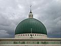
Bangsamoro is home to amazing natural places. These include Lake Lanao, which is one of the oldest lakes in the world. The area also has the Turtle Islands Wildlife Sanctuary, Bongao Peak, and the Basilan Rainforest.
Contents
About Bangsamoro
Bangsamoro is a unique part of the Philippines. It is an "autonomous region." This means it has its own government and laws. These laws are made to fit the needs of the people living there. The region is mostly made up of Muslim communities.
Where is Bangsamoro located?
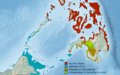
Bangsamoro is found in the southern part of the Philippines. It includes five provinces:
It also includes three cities:
- Cotabato City (which is its main center)
- Lamitan
- Marawi
There are also many smaller towns and villages.
What makes Bangsamoro special?
Bangsamoro is known for its rich culture and beautiful nature.
- Nature: It has Lake Lanao, a very old lake. The Turtle Islands Wildlife Sanctuary is also here. This place is important for protecting sea turtles. You can also find Bongao Peak and the Basilan Rainforest.
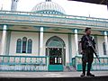
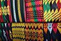
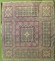
- Culture: The region has a long history. It is home to various Muslim groups. These groups have unique traditions, music, and art. They have their own special clothing and food.
How was Bangsamoro formed?
The Bangsamoro region was created to bring peace and development. People voted for it in 2019. This vote was called a "plebiscite." It allowed the people to decide if they wanted this new autonomous region. The creation of BARMM was a big step. It gave more power to the local communities. This helps them manage their own affairs.
Images for kids
-
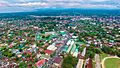
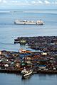
A view of Cotabato City as seen in February 2018
-
Approximate historical extent of the Muslim sultanates of Sulu, Maguindanao and Lanao
-
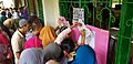
Voters look for their names at a precinct in Marawi during the January 21 BOL plebiscite.
-
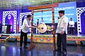
President Rodrigo Duterte sounds the agung during the inauguration of Bangsamoro. He is joined by Chief Minister Murad Ebrahim.
-
Marawi
-
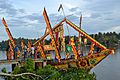
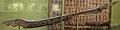
Ginakit boat of the Maguindanao people
-
Bacolod-Kalawi, Lanao del Sur
-
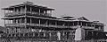
Daru Jambangan (Palace of Flowers) in Maimbung, Sulu before it was destroyed by a typhoon in 1932.
-
Inaul, a Maguindanaon woven cloth.
-
Bongao, Tawi-Tawi
-
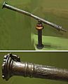
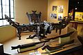
A Moro brass lantaka or swivel gun.
-
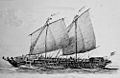
19th century illustration of a lanong, the main warships used by the Iranun and Banguingui people
-
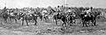
Tausūg horsemen in Sulu, taken on December 30, 1899.
-
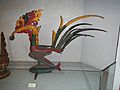
Sarimanok statue of the Maranao
-
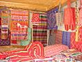
Yards of Yakan people's cloths
-
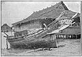
A Sama-Bajau lepa houseboat (c. 1905)
-
Pis siyabit (headscarf) of the Tausūgs
-
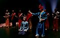
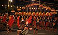
Tausūg dancers in traditional attire.
-
A kutiyapi of the Maguindanao people
-

A malong bearing okir designs.
-
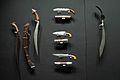
Moro blades made from Basilan "basih" (iron)
-
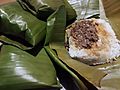
Pastil, a traditional Maguindanaon food.
-
Lami-Lamihan Festival
-
A Maranao kulintang ensemble with okir carvings

.png)


_Hospital_Ship_USNS_Mercy_(T-AH_19)_is_anchored_off_of_the_coast_of_Tawi_Tawi.jpg)
_from_the_Sulu_Archipelago,_brass,_Honolulu_Museum_of_Art.jpg)
.jpg)


.jpg)
,_Tausug_people,_Philippines,_Honolulu_Museum_of_Art_14451.1.JPG)
.jpg)


_01.jpg)


See also
 In Spanish: Bangsamoro para niños
