Bare Island (New Zealand) facts for kids

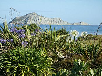
Motu o Kura / Bare Island as seen from the mainland
|
|
| Geography | |
|---|---|
| Location | Hawke's Bay |
| Coordinates | 39°49′59″S 177°01′39″E / 39.833125°S 177.027589°E |
| Area | 15 ha (37 acres) |
| Highest elevation | 106 m (348 ft) |
| Administration | |
|
New Zealand
|
|
| Demographics | |
| Population | 0 |
Motu o Kura / Bare Island is a small island in the Pacific Ocean. It is located in the southern Hawke's Bay region of New Zealand. You can find it off the eastern coast of the North Island.
The island is about 2 kilometers (1.2 miles) from the North Island coast. It is near a place called Waimārama. This is about 25 kilometers (15.5 miles) south of Cape Kidnappers.
On the southwest side of the island, there is a special place. It's an aquifer, which is like an underground spring. This aquifer provides fresh water. It is known as Nga Puhake-o-te-ora, meaning "the burp of life."
From the land, Motu o Kura looks quite bare. But from the ocean side, it has more plants and rocks. These spots are perfect resting places for blue penguins and sooty shearwaters.
In 1827, a sailor named Jules Dumont d'Urville sailed past the island. He saw houses and boats on the side facing the sea.
The island's name was officially changed in 2018. It became Motu o Kura / Bare Island. This happened after a special law was passed called the Heretaunga Tamatea Claims Settlement Act.
The Legend of Motu-o-Kura Island
The name Motu-O-Kura means "island of Kura." This comes from a Māori legend.
According to the story, Kura was a very strong woman. During times when her people were under attack, she would dive into the ocean. She would go to the aquifer behind the island. This place was called Te Puhake o te Ora, or "well of living waters." She did this to get fresh water, because there is no fresh water on Motu o Kura itself.
See also
 In Spanish: Isla Bare para niños
 | John T. Biggers |
 | Thomas Blackshear |
 | Mark Bradford |
 | Beverly Buchanan |

