Battambang province facts for kids
Quick facts for kids
Battambang
បាត់ដំបង
|
||
|---|---|---|
| Battambang Province ខេត្តបាត់ដំបង |
||
|
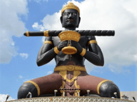
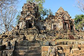
From top: Phnom Sampov, Wat Banan, Wat Sangkae, Kamping Puoy Lake
|
||
|
||

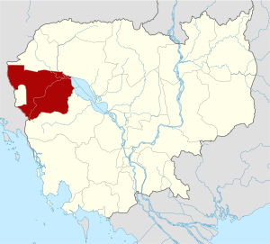
Map of Cambodia highlighting Battambang province
|
||
| Country | ||
| Siamese administration | 1795–1907 | |
| Provincial status | 6 December 1907 | |
| Capital | Battambang | |
| Subdivisions | 1 municipality; 13 districts | |
| Area | ||
| • Total | 11,702 km2 (4,518 sq mi) | |
| Area rank | 5th | |
| Population
(2019)
|
||
| • Total | ||
| • Rank | 5th | |
| • Density | 85/km2 (220/sq mi) | |
| • Density rank | 16th | |
| Time zone | UTC+07:00 (ICT) | |
| ISO 3166 code | KH-2 | |
| Battambang Province | |
|---|---|
| Khmer name | |
| Khmer | បាត់ដំបង
UNGEGN: Khétt Bătdâmbâng ALA-LC: Khett Pâtṭaṃpang IPA: [kʰaet ɓatɗɑmɓɑːŋ] |
Battambang (Khmer: បាត់ដំបង, Bătdâmbâng; meaning "Lost Stick") is a province in the far northwest of Cambodia. It shares borders with several other provinces like Banteay Meanchey and Siem Reap. Part of its western side also forms an international border with Thailand.
Battambang is the fifth most populated province in Cambodia. It is also the fifth largest in terms of land area. This province is known as "the rice bowl of Cambodia" because it has many fertile rice fields. This means farming is a big part of its economy. About 75% of the province is covered by jungles and mountains. The weather here is tropical, which means it's warm all year round.
Contents
What Does Battambang Mean?
The name Battambang comes from the Khmer words for 'loss of staff' or 'lost stick'. This name is linked to an old local story about a legendary figure called Preah Bat Dambang Kranhoung. Even though ancient stone writings don't mention "Battambang," old documents show that the name Srok Battambang (Battambang District) was used a long time ago. In Thai, the province is called Phra Tabong.
A Brief History of Battambang
Battambang's location made it important to both Siam (now Thailand) and Cambodia. Because of this, it was sometimes controlled by one kingdom and sometimes by the other. Most of the people living here are from the Khonpor or Chong ethnic groups.
In 1769, the King of Siam, Taksin, took control of Battambang and Siem Reap. Later, on March 23, 1907, Battambang, along with Siem Reap and Koh Kong, became part of French Indochina. During World War II, it was briefly controlled by Imperial Japan and then given to Thailand. After the war ended, Battambang was returned to an independent Cambodia.
How Battambang is Organized
Battambang province is divided into 13 districts and one main city area. These areas are then split into smaller parts called communes (khum) and quarters (sangkat). Inside these, there are many villages (phum).
| ISO code |
Name | Khmer | Population (2019) | Subdivisions | |
|---|---|---|---|---|---|
| — Main City — | |||||
| 02-03 | Battambang City | បាត់ដំបង | 119,251 | 10 sangkat | |
| — Districts — | |||||
| 02-01 | Banan | បាណន់ | 86,486 | 8 khum | |
| 02-02 | Thma Koul | ថ្មគោល | 105,982 | 10 khum | |
| 02-04 | Bavel | បវែល | 92,306 | 6 khum | |
| 02-05 | Aek Phnom | ឯកភ្នំ | 71,120 | 7 khum | |
| 02-06 | Moung Ruessei | មោងឫស្សី | 103,841 | 9 khum | |
| 02-07 | Rotanak Mondol | រតនមណ្ឌល | 38,848 | 4 khum | |
| 02-08 | Sangkae | សង្កែ | 111,118 | 10 khum | |
| 02-09 | Samlout | សំឡូត | 43,715 | 7 khum | |
| 02-10 | Sampov Loun | សំពៅលូន | 37,323 | 6 khum | |
| 02-11 | Phnum Proek | ភ្នំព្រឹក | 44,741 | 5 khum | |
| 02-12 | Kamrieng | កំរៀង | 53,076 | 6 khum | |
| 02-13 | Koas Krala | គាស់ក្រឡ | 30,192 | 6 khum | |
| 02-14 | Rukhak Kiri | រុក្ខគិរី | 42,329 | 5 khum | |
Historical Sites to Explore
Battambang is home to some amazing old temples and historical places.
Wat Ek Phnom Temple
Wat Ek Phnom (Khmer: វត្តឯកភ្នំ) is an ancient temple from the 11th century. It's located about 11 kilometers north of Battambang city. The temple is quite large, measuring 52 meters by 49 meters. You can still see parts of its old walls and a baray, which was an ancient water reservoir. Above the east entrance, there's a beautiful carving showing the "Churning of the Ocean of Milk," a famous story.
Wat Banan Temple
Wat Banan (Khmer: ភ្នំបាណន់) is about 25 kilometers south of Battambang city. Many people say it looks like a smaller version of the famous Angkor Wat. This temple is also from the 11th century and is built on a mountain. It's one of the best-preserved ancient Khmer temples in the area. As you get closer, you'll see five towers reaching towards the sky. To reach the temple, you need to climb over 350 steps, which are guarded by mythical snake-like creatures called nagas. Once you reach the top, you'll find a very peaceful place.
Getting Around Battambang
You can reach Battambang by road or by boat using the Sangkae River. National Highway 5 goes right through the province, making it easy to travel by car or bus. While there is an airport and a railway line, they are not currently in use. Buses are a popular way to get there, with trips from Phnom Penh taking about 5-6 hours and from Siem Reap about 3-4 hours.
See also
 In Spanish: Provincia de Battambang para niños
 | John T. Biggers |
 | Thomas Blackshear |
 | Mark Bradford |
 | Beverly Buchanan |


