
Siem Reap province facts for kids
Quick facts for kids
Siem Reap
សៀមរាប
|
||
|---|---|---|
| Siem Reap Province ខេត្តសៀមរាប |
||
   .jpg) From top: Angkor Wat,
South Gate of Angkor Thom, Phnom Kulen waterfall, moat of Angkor |
||
|
||
| Nickname(s):
Gateway to Angkor
|
||

Map of Cambodia highlighting Siem Reap
|
||
| Country | ||
| Settled | 802 | |
| Provincial status | 23 December 1907 | |
| Capital | Siem Reap | |
| Subdivisions | 1 municipality; 13 districts | |
| Area | ||
| • Total | 10,299 km2 (3,976 sq mi) | |
| Area rank | 10th | |
| Population
(2019)
|
||
| • Total | ||
| • Rank | 4th | |
| • Density | 98/km2 (250/sq mi) | |
| • Density rank | 13th | |
| Time zone | UTC+07:00 (ICT) | |
| ISO 3166 code | KH-17 | |

Siem Reap (pronounced See-em Reep) is a province in the country of Cambodia. It's officially called Siemreap in the local language, Khmer. This province is located in the northwest part of Cambodia. It shares borders with several other provinces. The capital and largest city of the province is also called Siem Reap.
Siem Reap province is the tenth largest province in Cambodia. In 2019, its population reached over one million people. This makes it the fourth most populated province in the country. A big part of its southern border is along the Tonle Sap lake. This lake is a special area called the Tonle Sap Biosphere Reserve.
Today, Siem Reap province is famous for being home to Angkor. This includes the amazing Angkor Wat temple ruins. Angkor Wat is a UNESCO World Heritage Site. Other important places here are Banteay Srei, the Roluos temples, and Beng Mealea. You can also find Phnom Kulen National Park here. It has Cambodia's largest reclining Buddha statue.
Contents
What Does Siem Reap Mean?
The name Siem Reap has a special meaning. It literally means 'Siam defeated'. This name reminds people of old conflicts. These were fights between the Siamese (from Thailand) and the Khmer (from Cambodia). In Thailand, this area was called Siemmarat. This name meant 'Siam's territory'.
A Look at Siem Reap's History
Siem Reap province was once controlled by the Thai kingdom of Siam. This happened in 1795. Later, in 1907, it became part of Cambodia again. This change happened because France made a deal with Siam. Siam traded this area for other lands.
The area was then divided into two provinces: Battambang and Siem Reap. This was done by King Sisowath. For some time, this region was a disputed area. This led to the Franco-Thai War in 1941. Thailand won this war and took back control. However, Siem Reap and Angkor Wat stayed with Cambodia. After World War II, in 1946, the province fully returned to Cambodia. This was due to pressure from France and the UN.
Religions in Siem Reap
Religion in Siem Reap province (2019 census) Buddhism (99.3%) Christianity (0.4%) Islam (0.2%) Animism and Other religions (0.1%)
The main religion in Cambodia is Theravada Buddhism. Most people in Siem Reap province are Buddhists. About 99.3% of the population follows Buddhism. A smaller number of people, about 0.4%, are Christians. Islam is followed by about 0.2% of the people. Many of these are Chams.
How Siem Reap is Divided
The province is split into different parts. It has one main city area, called a municipality. It also has 11 districts. These districts are further divided into 100 communes. Inside these communes, there are 907 villages.
| ISO code |
Name | Khmer | Subdivisions | ||
|---|---|---|---|---|---|
| — Municipality — | |||||
| 17-10 | Siem Reap | សៀមរាប | 12 sangkat | ||
| — District — | |||||
| 17-01 | Angkor Chum | អង្គរជុំ | 7 khum | ||
| 17-02 | Angkor Thom | អង្គរធំ | 4 khum | ||
| 17-03 | Banteay Srei | បន្ទាយស្រី | 6 khum | ||
| 17-04 | Chi Kraeng | ជីក្រែង | 12 khum | ||
| 17-06 | Kralanh | ក្រឡាញ់ | 10 khum | ||
| 17-07 | Puok | ពួក | 14 khum | ||
| 17-09 | Prasat Bakong | ប្រាសាទបាគង | 9 khum | ||
| 17-11 | Soutr Nikom | សូត្រនិគម | 10 khum | ||
| 17-12 | Srei Snam | ស្រីស្នម | 6 khum | ||
| 17-13 | Svay Leu | ស្វាយលើ | 5 khum | ||
| 17-14 | Varin | វ៉ារិន | 5 khum | ||
Gallery
-
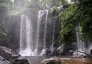
Phnom Kulen is a beautiful mountain.
-
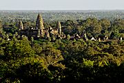
You can see Angkor Wat from Phnom Bakheng.
-
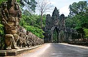
This is the South Gate of Angkor Thom.
-
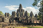
The Bayon Temple has many faces carved into it.
-
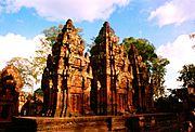
Banteay Srei is known for its pink sandstone carvings.


See also

In Spanish: Provincia de Siem Riep para niños
