Baviácora facts for kids
Baviácora is a small, charming town in the Mexican state of Sonora. It's also the main town, or "municipal seat," for the area around it, called the Baviácora Municipality. You can find it by its special location coordinates: 29°42′N 110°09′W / 29.700°N 110.150°W.
Contents
Where is Baviácora?
Baviácora is located almost in the center of the Sonora state. It's about 125 kilometers (about 78 miles) away from Hermosillo, which is the capital city of Sonora. The town sits in the valley of the Río Sonora, a local river.
Neighboring Areas
Baviácora shares its borders with several other towns and areas:
- To the north is Aconchi.
- To the south are Ures and Villa Pesqueira.
- To the east is Cumpas.
- To the west are Ures and Rayón.
The town itself is about 620 meters (2,034 feet) above sea level.
What's the Weather Like?
Baviácora has a hot and dry climate.
- From June to September, the average high temperature is around 30.1°C (86.2°F).
- From December to January, the average low temperature is about 13.5°C (56.3°F).
- The average temperature for the whole year is about 22.7°C (72.9°F).
How Big is Baviácora?
The entire Baviácora municipality covers an area of 858.96 square kilometers (about 331.65 square miles). In 2005, about 3,404 people lived in the municipality. Around 1,974 of those people lived right in the main town of Baviácora in the year 2000.
What Do People Do for Work?
The economy in Baviácora mostly depends on farming and raising cattle.
- Farmers mainly grow corn and beans.
- They also grow special grasses to feed the cattle.
- In 2000, there were more than 17,000 cattle in the area!
There are also some small local businesses and one factory that makes clothes.
Places to Visit
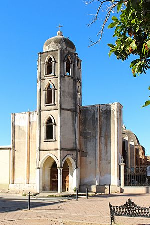
The most important place to visit in Baviácora is the old mission church. It's called the "Nuestra Señora de la Concepción de Baviácora" mission church. It's a beautiful and historic building.
A Look Back in Time
The history of Baviácora is quite interesting:
- In 1639, a Jesuit missionary from Portugal named Bartolomé Castaños started the mission here. He named it Nuestra Señora de la Concepción de Baviácora.
- The name "Baviácora" comes from the Opata language. It means "babícori," which is a type of mint plant that grows along the Río Sonora.
- Before the mission was built, the Opata people who lived here were conquered by a Spanish general named Pedro de Perea in 1639.
- Baviácora officially became its own municipality in 1931.
See also
 In Spanish: Baviácora para niños
 | Sharif Bey |
 | Hale Woodruff |
 | Richmond Barthé |
 | Purvis Young |


