Iron River Township, Michigan facts for kids
Quick facts for kids
Iron River Township, Michigan
|
|
|---|---|

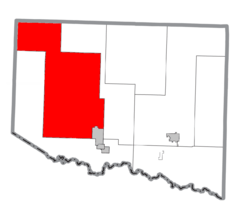
Location within Iron County
|
|
| Country | United States |
| State | Michigan |
| County | Iron |
| Area | |
| • Total | 243.9 sq mi (631.8 km2) |
| • Land | 239.6 sq mi (620.4 km2) |
| • Water | 4.4 sq mi (11.3 km2) |
| Elevation | 1,568 ft (478 m) |
| Population
(2020)
|
|
| • Total | 1,052 |
| • Density | 6.6/sq mi (2.6/km2) |
| Time zone | UTC-6 (Central (CST)) |
| • Summer (DST) | UTC-5 (CDT) |
| ZIP code |
49935
|
| Area code(s) | 906 |
| FIPS code | 26-41000 |
| GNIS feature ID | 1626527 |
Iron River Township is a special kind of local government area called a civil township. It is located in Iron County in the state of Michigan, USA. In 2020, about 1,052 people lived here.
What is Iron River Township Like?
Iron River Township covers a large area. Most of it is land, but it also includes some water. The total area is about 243.9 square miles (631.8 square kilometers). Of this, about 239.6 square miles (620.4 square kilometers) is land. The rest, about 4.4 square miles (11.3 square kilometers), is water.
Nearby Communities
The City of Iron River is very close to the township. It sits at the southeast corner. However, the city is run separately from the township.
Beechwood Community
Beechwood is a small, unincorporated community within Iron River Township. This means it's a group of homes and businesses that isn't officially a city or town with its own government. Beechwood is located northwest of the City of Iron River.
The community got its name from a group of beech trees that grew nearby. In 1888, Beechwood became a stop on the Chicago and North Western Transportation Company railway line. A post office was opened there in November 1889. It stayed open until January 1976.
See also
 In Spanish: Municipio de Iron River para niños
 | Frances Mary Albrier |
 | Whitney Young |
 | Muhammad Ali |


