Iron County, Michigan facts for kids
Quick facts for kids
Iron County
|
|
|---|---|

|
|

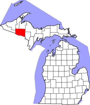
Location within the U.S. state of Michigan
|
|
 Michigan's location within the U.S. |
|
| Country | |
| State | |
| Founded | April 3, 1885 |
| Named for | Iron ore |
| Seat | Crystal Falls |
| Largest city | Iron River |
| Area | |
| • Total | 1,211 sq mi (3,140 km2) |
| • Land | 1,166 sq mi (3,020 km2) |
| • Water | 45 sq mi (120 km2) 3.7%% |
| Population
(2020)
|
|
| • Total | 11,631 |
| • Density | 10/sq mi (4/km2) |
| Time zone | UTC−6 (Central) |
| • Summer (DST) | UTC−5 (CDT) |
| Congressional district | 1st |
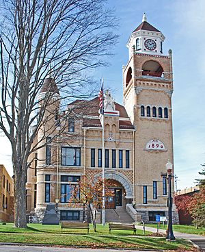
Iron County is a place in the Upper Peninsula of Michigan, a state in the United States. It's one of only two counties in this area that doesn't touch a large body of water.
In 2020, about 11,631 people lived here. The main town and government center is Crystal Falls.
Contents
History of Iron County
Iron County was officially created in 1885. It was formed from parts of Marquette and Menominee counties.
In 1890, the county had 4,432 residents. It got its name from the valuable iron ore found in the ground. This ore was very important to the area's early growth.
Geography and Nature
The U.S. Census Bureau says Iron County covers about 1,211 square miles. Most of this area, 1,166 square miles, is land. The remaining 45 square miles, or 3.7%, is water.
Like its neighbor Dickinson County, Iron County is landlocked. This means it doesn't border any large lakes or oceans.
Main Roads in Iron County
Several important roads run through Iron County:
 US 2 – This road goes east and west through the southern part of the county. It passes through towns like Mineral Hills, Iron River, and Fortune Lake.
 US 141 – This road travels north and south through the middle of the county. It connects to US-2 in Crystal Falls.
 M-69 – This road goes east from Crystal Falls into Dickinson County.
 M-73 – This road enters from Wisconsin and goes northeast to meet US-2 in Iron River.
- M-189 – This road also comes from Wisconsin and goes north to meet US-2 in Iron River.
Neighboring Counties
Iron County shares borders with several other counties:
- Houghton County (north)
- Baraga County (north)
- Marquette County (northeast)
- Dickinson County (east)
- Florence County, Wisconsin (southeast)
- Forest County, Wisconsin (south)
- Vilas County, Wisconsin (southwest)
- Gogebic County (west)
- Ontonagon County (northwest)
Protected Natural Areas
Part of the Ottawa National Forest is located within Iron County. This is a large area of protected land.
Towns and Communities
Iron County has several cities, a village, and other smaller communities.
Cities
- Caspian
- Crystal Falls (This is the county seat, where the main government offices are)
- Gaastra
- Iron River
Village
Census-Designated Place
Smaller Communities
These are smaller places that are not officially cities or villages:
- Beechwood
- Colony Corners
- Elmwood
- Erickson Landing
- Forbes
- Fortune Lake
- Gibbs City – This used to be a town on the Paint River.
- Mansfield Location
- Pentoga
- Rogers
- Stager
Townships
Iron County is also divided into several townships:
- Bates Township
- Crystal Falls Township
- Hematite Township
- Iron River Township
- Mansfield Township
- Mastodon Township
- Stambaugh Township
Population Facts
| Historical population | |||
|---|---|---|---|
| Census | Pop. | %± | |
| 1890 | 4,432 | — | |
| 1900 | 8,990 | 102.8% | |
| 1910 | 15,164 | 68.7% | |
| 1920 | 22,107 | 45.8% | |
| 1930 | 20,805 | −5.9% | |
| 1940 | 20,243 | −2.7% | |
| 1950 | 17,692 | −12.6% | |
| 1960 | 17,184 | −2.9% | |
| 1970 | 13,813 | −19.6% | |
| 1980 | 13,635 | −1.3% | |
| 1990 | 13,175 | −3.4% | |
| 2000 | 13,138 | −0.3% | |
| 2010 | 11,817 | −10.1% | |
| 2020 | 11,631 | −1.6% | |
| 2023 (est.) | 11,740 | −0.7% | |
| US Decennial Census 1790-1960 1900-1990 1990-2000 2010-2018 |
|||
In 2020, the population of Iron County was 11,631 people. This was a small decrease from the 2010 population of 11,817.
Most people in Iron County are of White background (97.1%). Other groups include Native American (2.9%) and Asian (0.3%). About 1.4% of the population identifies as Hispanic or Latino.
Many families in Iron County have roots from different countries. Common backgrounds include German, Finnish, Italian, French, Swedish, English, and Irish.
The average age of people in Iron County is about 51.9 years old. This means there are many adults and older people living there.
Schools in Iron County
Students in Iron County attend schools in these districts:
- West Iron County Schools
- Forest Park School District
See also
 In Spanish: Condado de Iron (Míchigan) para niños
 | Mary Eliza Mahoney |
 | Susie King Taylor |
 | Ida Gray |
 | Eliza Ann Grier |


