Florence County, Wisconsin facts for kids
Quick facts for kids
Florence County
|
|
|---|---|

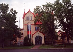
Florence County Courthouse
|
|

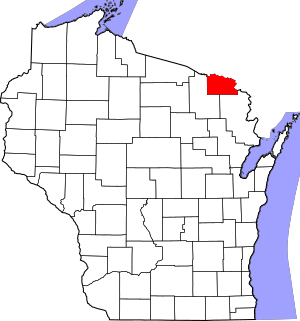
Location within the U.S. state of Wisconsin
|
|
 Wisconsin's location within the U.S. |
|
| Country | |
| State | |
| Founded | 1882 |
| Named for | Florence Terry Hulst |
| Seat | Florence |
| Largest town | Florence |
| Area | |
| • Total | 498 sq mi (1,290 km2) |
| • Land | 488 sq mi (1,260 km2) |
| • Water | 9.3 sq mi (24 km2) 1.9% |
| Population
(2020)
|
|
| • Total | 4,558 |
| • Estimate
(2023)
|
4,682 |
| • Density | 9.3/sq mi (3.6/km2) |
| Time zone | UTC−6 (Central) |
| • Summer (DST) | UTC−5 (CDT) |
| Congressional district | 7th |
Florence County is a place in the state of Wisconsin, USA. In 2020, about 4,558 people lived there. This makes it the second smallest county in Wisconsin by population. Only Menominee County has fewer people.
The main town, or county seat, where the county government is, is called Florence. Florence County is also part of a larger area that includes Iron Mountain, Michigan. This area is called a Micropolitan Statistical Area. It means it's a small city area with nearby towns that are connected.
Contents
History of Florence County
Florence County was officially started in 1882. It was made from parts of two other counties: Marinette County and Oconto County. The state government, called the legislature, decided to create it.
The first European person to write about traveling through Florence County was Thomas J. Cram. He explored and mapped northeast Wisconsin in 1840 and 1841. Before that, the land belonged to the Menominee tribe. They often met and lived with the Chippewa tribe in this area.
Florence County was mostly used for hunting and trapping until the 1870s. That's when people found iron in the ground. The Florence mine was discovered in 1874 by H. D. Fisher. In 1879, Fisher named the mine and the town after Florence Terry Hulst. She was the wife of Nelson Powell Hulst. This is how the county got its name too!
Geography of Florence County
According to the U.S. Census Bureau, Florence County covers about 498 square miles. Most of this area, about 488 square miles, is land. The rest, about 9.3 square miles, is water. This means about 1.9% of the county is water.
Neighboring Counties
Florence County shares borders with these other counties:
- Iron County, Michigan - to the north
- Dickinson County, Michigan - to the east
- Marinette County, Wisconsin - to the southeast
- Forest County, Wisconsin - to the southwest
Main Roads
These are the most important highways that go through Florence County:
Protected Natural Areas
Part of the Nicolet National Forest is located in Florence County. This is a large area of protected land.
People in Florence County (Demographics)
| Historical population | |||
|---|---|---|---|
| Census | Pop. | %± | |
| 1890 | 2,604 | — | |
| 1900 | 3,197 | 22.8% | |
| 1910 | 3,381 | 5.8% | |
| 1920 | 3,602 | 6.5% | |
| 1930 | 3,768 | 4.6% | |
| 1940 | 4,177 | 10.9% | |
| 1950 | 3,756 | −10.1% | |
| 1960 | 3,437 | −8.5% | |
| 1970 | 3,298 | −4.0% | |
| 1980 | 4,172 | 26.5% | |
| 1990 | 4,590 | 10.0% | |
| 2000 | 5,088 | 10.8% | |
| 2010 | 4,423 | −13.1% | |
| 2020 | 4,558 | 3.1% | |
| 2021 (est.) | 4,593 | 3.8% | |
| U.S. Decennial Census 1790–1960 1900–1990 1990–2000 2010–2020 |
|||
What the 2020 Census Showed
In 2020, the population of Florence County was 4,558 people. There were about 9.3 people living in each square mile. The county also had 4,601 homes.
Most of the people living in Florence County were White (94.6%). A smaller number were Native American (0.7%), Black or African American (0.2%), or Asian (0.2%). Some people were from two or more racial backgrounds (3.9%). About 1.4% of the population identified as Hispanic or Latino.
Communities in Florence County
Florence County is special because it's one of only two counties in Wisconsin that doesn't have any incorporated communities. This means there are no official cities or villages with their own separate governments. The other county like this is Menominee County.
Towns
Unincorporated Communities
These are smaller communities that are not officially part of a town or village.
See also
 In Spanish: Condado de Florence (Wisconsin) para niños
 | Dorothy Vaughan |
 | Charles Henry Turner |
 | Hildrus Poindexter |
 | Henry Cecil McBay |


