
Menominee County, Wisconsin facts for kids
Quick facts for kids
Menominee County
|
|
|---|---|

Menominee Indian Tribal Offices in Keshena, Wisconsin
|
|

Location within the U.S. state of Wisconsin
|
|
 Wisconsin's location within the U.S. |
|
| Country | |
| State | |
| Founded | July 3, 1959 |
| Named for | Menominee tribe |
| Seat | Keshena |
| Largest town | Menominee |
| Area | |
| • Total | 365 sq mi (950 km2) |
| • Land | 358 sq mi (930 km2) |
| • Water | 7.4 sq mi (19 km2) 2.0%% |
| Population
(2020)
|
|
| • Total | 4,255 |
| • Estimate
(2023)
|
4,226 |
| • Density | 11.9/sq mi (4.6/km2) |
| Time zone | UTC−6 (Central) |
| • Summer (DST) | UTC−5 (CDT) |
| Congressional district | 8th |
Menominee County is a special area in Wisconsin, a state in the United States. It's called a county, which is like a smaller region within a state. In 2020, about 4,255 people lived here. This makes it the county with the fewest people in all of Wisconsin! The main town, or county seat, where the government offices are, is called Keshena.
Menominee County is Wisconsin's newest county. It was created in 1959. This happened after the Menominee tribe's special status was changed by a federal law. But in 1974, the tribe got back its federal recognition. This also meant they got back most of their original land. Today, Menominee County is almost exactly the same as the Menominee Indian Reservation. This means the county and the reservation share the same borders.
Contents
A Special History
Menominee County was formed on July 3, 1959. It was made from parts of Shawano County and Oconto County. This was done because the special status of the Menominee Indian Reservation was going to end in 1961. However, the reservation's status was brought back in 1973. Now, the county and the reservation cover the same area.
Most of the land in Menominee County is held in trust by the federal government. This land is for the exclusive use of members of the Menominee nation. Some small pieces of land were bought by non-Native Americans when the reservation status was changed. Also, many lots around Legend Lake are privately owned. These are the only parts of the county not owned by the tribe. Most people living in Menominee County are members of the Menominee nation.
Where is Menominee County?
The U.S. Census Bureau says Menominee County covers about 365 square miles. Out of this, 358 square miles are land, and 7.4 square miles are water. The water makes up about 2% of the county's total area. It is the second-smallest county in Wisconsin by its total size.
Nearby Places
Menominee County shares borders with these other counties:
- Oconto County to the east
- Shawano County to the south
- Langlade County to the northwest
Main Roads
These are the most important highways that go through Menominee County:
 Highway 47 (Wisconsin)
 Highway 55 (Wisconsin)
Who Lives in Menominee County?
As of the 2020 census, there were 4,255 people living in Menominee County. There were 1,400 households and 1,064 families. The county has about 11.9 people per square mile. Most of the people in Menominee County are Native American, making up about 85.6% of the population. About 11.8% of the people are White. A small number of people are from other backgrounds. About 3.2% of the population is Hispanic or Latino.
Towns and Villages


Menominee County is one of only two counties in Wisconsin without any big, official cities or towns. The other is Florence County.
Town
- Menominee (This is the name of the only town area in the county, which covers the whole county.)
Census-designated places
These are smaller communities that the census bureau keeps track of:
- Keshena (This is the county seat, where the main offices are.)
- Legend Lake
- Middle Village (Only part of it is in Menominee County.)
- Neopit
- Zoar
Old or Abandoned Places
- Perote (This was once a community but is now a ghost town or neighborhood.)
Images for kids
-
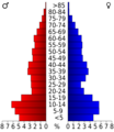
This chart shows the age groups of people in Menominee County from the 2000 Census.

See also
 In Spanish: Condado de Menominee (Wisconsin) para niños
