Hematite Township, Michigan facts for kids
Quick facts for kids
Hematite Township, Michigan
|
|
|---|---|

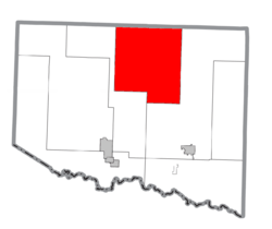
Location within Iron County
|
|
| Country | United States |
| State | Michigan |
| County | Iron |
| Area | |
| • Total | 155.8 sq mi (403.4 km2) |
| • Land | 153.5 sq mi (397.4 km2) |
| • Water | 2.3 sq mi (6.0 km2) |
| Elevation | 1,499 ft (457 m) |
| Population
(2020)
|
|
| • Total | 269 |
| • Density | 2.3/sq mi (0.9/km2) |
| Time zone | UTC-6 (Central (CST)) |
| • Summer (DST) | UTC-5 (CDT) |
| FIPS code | 26-37580 |
| GNIS feature ID | 1626462 |
Hematite Township is a special kind of local government area called a civil township. It is located in Iron County in the U.S. state of Michigan. In the year 2000, about 352 people lived here. By 2020, the population was 269. The township gets its name from the large amounts of hematite iron ore found in the rocks nearby. Hematite is a type of rock that contains iron.
Geography of Hematite Township
Hematite Township covers a total area of about 155.8 square miles (403.4 square kilometers). Most of this area, about 153.4 square miles (397.4 square kilometers), is land. The rest, about 2.3 square miles (6.0 square kilometers), is water.
Communities in the Township
- Amasa is a small, unincorporated community within Hematite Township. This means it's a recognized place but doesn't have its own separate local government. Amasa is located along U.S. Highway 141. The Hemlock River also crosses through this area. The community was named after Amasa Stone, who was from Cleveland, Ohio. If you wanted to send mail to Amasa, the ZIP code is 49903.
See also
 In Spanish: Municipio de Hematite para niños
Black History Month on Kiddle
African-American Women in Medicine:
 | May Edward Chinn |
 | Rebecca Cole |
 | Alexa Canady |
 | Dorothy Lavinia Brown |

All content from Kiddle encyclopedia articles (including the article images and facts) can be freely used under Attribution-ShareAlike license, unless stated otherwise. Cite this article:
Hematite Township, Michigan Facts for Kids. Kiddle Encyclopedia.

