Belén de Bajirá facts for kids
Quick facts for kids
Belén de Bajirá
|
|
|---|---|
|
Corregimiento and town
|
|

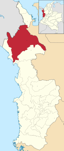
Location of the corregimiento and town of Belén de Bajirá in Chocó Department of Colombia
|
|
| Country | Colombia |
| Department | Chocó Department |
| Municipality | Riosucio, Chocó |
| Area | |
| • Total | 2,015 km2 (778 sq mi) |
| Population | |
| • Total | 13,438 |
| • Density | 6.6690/km2 (17.273/sq mi) |
| Time zone | UTC-05:00 (Colombia Standard Time) |
Belén de Bajirá is a town in Colombia. It is located in the northwestern part of the country. For a long time, two regions, Antioquia and Chocó, argued over who owned this land. Chocó said Belén de Bajirá was part of its area, specifically the municipality of Riosucio. But Antioquia believed it was part of their municipality, Mutatá. This disagreement caused a big legal case.
Contents
What is Belén de Bajirá?
Belén de Bajirá is a small town. It was once a corregimiento, which is like a small district within a larger municipality. The town became well-known because of a long argument about its land.
The Land Dispute Explained
The conflict started when Chocó tried to make Belén de Bajirá its own municipality in the year 2000. A municipality is a self-governing area. Antioquia's leaders in Medellín said that this new municipality was actually on their land. They took the case to the Council of State of Colombia in Bogotá, which is a high court. Chocó, however, strongly defended its decision. They said the town was legally on their side.
How the Dispute Was Solved
The Geographic Institute Agustin Codazzi (IGAC) helped solve the problem. This group is in charge of making maps for Colombia. They looked at the old maps and laws. IGAC decided that the borders between the two regions were clear. They confirmed that Belén de Bajirá truly belonged to Chocó. This decision was based on a law from 1947 that set Chocó's borders. Because of this, new maps of Colombia now show Belén de Bajirá as part of Chocó.
Natural Resources and Economy
Even though the area is rich in natural resources, many people living there are not wealthy. The land has valuable things like gold, nickel, copper, and oil. There are also many oil palm trees. These resources could help the community grow.
Becoming a Municipality
In December 2022, Belén de Bajirá officially became its own municipality. This means it is now a separate, self-governing area. It is no longer just a part of Riosucio.
Climate
Belén de Bajirá has a tropical rainforest climate. This means it is warm all year round. It also gets a lot of rain, especially from April to November. The weather is usually hot and humid.
| Climate data for Belén de Bajirá | |||||||||||||
|---|---|---|---|---|---|---|---|---|---|---|---|---|---|
| Month | Jan | Feb | Mar | Apr | May | Jun | Jul | Aug | Sep | Oct | Nov | Dec | Year |
| Mean daily maximum °C (°F) | 30.1 (86.2) |
30.3 (86.5) |
30.9 (87.6) |
30.9 (87.6) |
29.4 (84.9) |
29.5 (85.1) |
29.8 (85.6) |
29.7 (85.5) |
29.2 (84.6) |
28.9 (84.0) |
29.0 (84.2) |
29.2 (84.6) |
29.7 (85.5) |
| Daily mean °C (°F) | 26.1 (79.0) |
26.5 (79.7) |
27.0 (80.6) |
26.9 (80.4) |
26.2 (79.2) |
26.1 (79.0) |
26.3 (79.3) |
26.2 (79.2) |
26.0 (78.8) |
25.8 (78.4) |
25.8 (78.4) |
25.8 (78.4) |
26.2 (79.2) |
| Mean daily minimum °C (°F) | 22.2 (72.0) |
22.8 (73.0) |
23.1 (73.6) |
23.0 (73.4) |
23.1 (73.6) |
22.8 (73.0) |
22.9 (73.2) |
22.8 (73.0) |
22.9 (73.2) |
22.8 (73.0) |
22.7 (72.9) |
22.5 (72.5) |
22.8 (73.0) |
| Average rainfall mm (inches) | 110 (4.3) |
96 (3.8) |
97 (3.8) |
308 (12.1) |
449 (17.7) |
482 (19.0) |
451 (17.8) |
502 (19.8) |
434 (17.1) |
481 (18.9) |
432 (17.0) |
304 (12.0) |
4,146 (163.3) |
See also
 In Spanish: Belén de Bajirá para niños
 | Claudette Colvin |
 | Myrlie Evers-Williams |
 | Alberta Odell Jones |


