
Belait District facts for kids
Quick facts for kids
Belait
Daerah Belait
دأيره بلأيت |
|
|---|---|
|
Daerah (District)
|
|
| Belait District | |
 |
|
| Capital | Kuala Belait |
| Area | |
| • Belait District | 2,727 km2 (1,053 sq mi) |
| Population | |
| • Belait District | 73,200 |
| • Density | 26.843/km2 (69.52/sq mi) |
| Postal code |
Kxxxxx
|
| Calling code | +673 3XX, +673 322 Seria, +673 323 Labi |
| Website | http://www.belait.gov.bn |
Belait District is the largest of the four districts in Brunei, a country in Southeast Asia. Its capital city is Kuala Belait, which is an important town in the district.
Contents
About Belait District
Belait District covers a large area of 2,727 square kilometers. This makes it the biggest district in Brunei. As of 2018, about 73,200 people live here. The district is known for its natural beauty and important industries.
Geography and Nature
Belait District is located on the western side of Brunei. To its north, you'll find the South China Sea, which is a large part of the Pacific Ocean. The district is also home to the Belait River, which is the longest river in Brunei. This river flows through the district and is very important for local life and transportation.
How Belait is Organized (Mukims)
Like other districts in Brunei, Belait is divided into smaller areas called mukims. These are like subdistricts or townships. Belait District has eight mukims:
- Bukit Sawat
- Kuala Balai
- Kuala Belait
- Labi
- Liang
- Melilas
- Seria
- Sukang
Images for kids
-
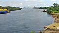
Belait River
-
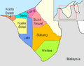
Mukims of Belait District


See also
 In Spanish: Distrito de Belait para niños
