
Belmore Park facts for kids
Quick facts for kids Belmore Park |
|
|---|---|

Belmore Park next to Central Station (1920s)
|
|
| Location | Hay Street, Eddy Avenue, Elizabeth Street and Pitt Street, Sydney, New South Wales, Australia |
| Created | 19 May 1868 |
| Etymology | Somerset Lowry-Corry, 4th Earl Belmore |
| Operated by | Sydney City Council |
| Status | Open all year |
Belmore Park is a public park located in the southern part of Sydney's city centre in New South Wales, Australia. It's right next to Central Station. The park is surrounded by Hay Street, Eddy Avenue, Elizabeth Street, and Pitt Street. Before it became a park, this area was known as Police Paddock. It was part of a larger piece of land owned by the government, which also included police buildings, a cemetery, and other community places.
Contents
A Park's Journey: How Belmore Park Began
The area was made into a park and officially opened in 1868. It was named after Somerset Lowry-Corry, 4th Earl Belmore, who was the Governor of New South Wales at that time.
In 1901, the entire area was taken over by the government to build Sydney's Central railway station. A lot of the dirt dug up for the station was placed on the park land, which changed its original shape. Later, in 1908–1909, a special group called a "Royal Commission" looked at ways to improve Sydney. They suggested big changes for the park area.
Belmore Park: A Hub for Events and People
Because it's so close to the city and Central Station, Belmore Park has always been a popular spot for people to gather. Groups use it for protests, markets, special events, or performances.
For example, in 1878, a man named Henri L'Estrange tried to launch himself into the sky in a hot air balloon right here! Many people came to watch, but his attempts were not successful. Years later, during the 2000 Summer Olympics, Belmore Park became one of five "live sites" in Sydney. This meant people could watch the Olympic Games broadcast live on big screens in the park.
In the late 1860s, "Belmore Produce Markets" and Paddy's Markets were built across from where the park is now. This area is known today as Haymarket.
Getting Around: Transport at Belmore Park
Belmore Park is a very important place for public transport. The railway tracks that go above ground end at the eastern side of the park before going underground as part of the City Circle train line.
Buses heading towards Sydney's Eastern Suburbs, including express buses to the University of New South Wales, leave from Eddy Avenue, which runs along the park. The new CBD and South East Light Rail also runs along Eddy Avenue.
The western side of the park has a road ramp that leads up to the main area of the railway station. The Inner West Light Rail line also circles the entire park, using ramps on both the eastern and western sides to reach the train station concourse.
Gallery
-
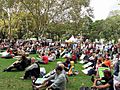
A climate change rally in the park, 2011
-
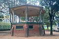
A bandstand, built in 1910, which is no longer used


