Berrocalejo de Aragona facts for kids
Quick facts for kids
Berrocalejo de Aragona
|
|||
|---|---|---|---|
 |
|||
|
|||

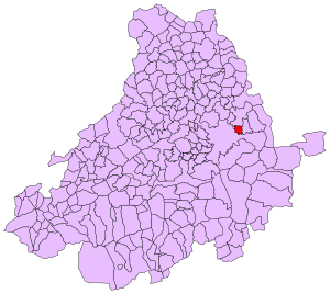
Extension of the municipal term within the province of Ávila
|
|||
| Country | |||
| Autonomous community | |||
| Province | |||
| Municipality | Berrocalejo de Aragona | ||
| Area | |||
| • Total | 9.01 km2 (3.48 sq mi) | ||
| Elevation | 1,092 m (3,583 ft) | ||
| Population
(2018)
|
|||
| • Total | 43 | ||
| • Density | 4.77/km2 (12.36/sq mi) | ||
| Time zone | UTC+1 (CET) | ||
| • Summer (DST) | UTC+2 (CEST) | ||
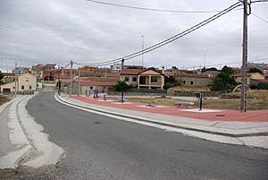
Berrocalejo de Aragona is a small town, also called a municipality (which is like a local government area), located in the province of Ávila in Castile and León, Spain. In 2004, about 52 people lived there. By 2018, the population was 43.
Contents
Life in Berrocalejo de Aragona
Berrocalejo de Aragona is a quiet place. Most people living here work in general activities. Some work in construction, like building or repairing things. A smaller number of people work in shops or provide services to others.
Local Government and the Mayor
The town has a mayor who helps run things. The current mayor is Emilio Navas Arroyo. He works to make the town better for everyone.
Connecting with the World
Even though it's a small town, Berrocalejo de Aragona is trying to connect with more people. They have created a new website and something called a "virtual town hall." This helps them share information and communicate with people online, making their presence known to a wider audience.
Geography and Location
Berrocalejo de Aragona is located in a beautiful part of Spain. It sits at an elevation of 1092 meters (about 3,583 feet) above sea level. This means it's quite high up, which can lead to nice views and cooler weather.
Where is it on the Map?
The town is in the province of Ávila, which is part of the larger region of Castile and León in central Spain. Its exact location is 40°41′39″N latitude and 4°35′49″W longitude.
See also
 In Spanish: Berrocalejo de Aragona para niños


