Bingöl facts for kids
Quick facts for kids
Bingöl
|
|
|---|---|
 |
|
| Country | Turkey |
| Province | Bingöl |
| District | Bingöl |
| Elevation | 1,120 m (3,670 ft) |
| Population
(2022)
|
133,423 |
| Time zone | TRT (UTC+3) |
| Postal code |
12000
|
| Area code | 0426 |
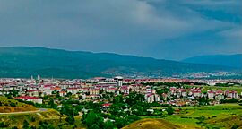
Bingöl is a city in Turkey. It was known as Çapakçur before 1944. Bingöl is the main city of Bingöl Province and Bingöl District. In 2022, about 133,423 people lived there.
Contents
Etymology
The name Bingöl means "thousand lakes" in Turkish. Even though there are no very big lakes in the province, the name refers to the many small mountain lakes, called tarns, found around the city.
History
Bingöl is located in an area that was once called Sophene. This was first an independent kingdom, then part of the Armenian and Roman empires. An Armenian historian from the 11th century, Stepanos Asoghik, mentioned the settlement by its Armenian name, Chapaghjur. He wrote about it when describing an earthquake in 995. Some people think Chapaghjur might be the same as the Roman fortress-town of Citharizum.
In the Middle Ages, Bingöl was called Romanoupolis. This name came from the Byzantine emperor Romanos I Lekapenos. He made it part of the Byzantine Empire in 942. It was first a small part of a larger area called Mesopotamia. Later, around 970, it became its own separate region.
Bingöl was ruled by the Suwaydid family from the 13th century. They ruled on their own, even when the Ottomans were in charge. A long time ago, many Armenian people lived in Bingöl and the areas nearby. Until the mid-1900s, the city was still known as Çapakçur. In 1944, its name was changed to Bingöl.
Geography
Bingöl is about 144 kilometers (89 miles) east of Elazığ. It is in the high mountain region of Eastern Anatolia. Bingöl is a very mountainous area, with some peaks reaching 3,000 meters (9,800 feet) high. The city itself is about 1,120 meters (3,670 feet) above sea level. The Gayt River flows through the city. This river is a branch of the Eastern Euphrates, also known as the Murat River.
Climate
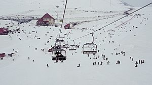
Bingöl has a continental climate. This means it has hot, dry summers and cold, snowy winters. The driest months are July and August. The wettest months are February and December.
- Highest recorded temperature: 42.0 °C (107.6 °F) on 26 July 2001
- Lowest recorded temperature: -25.1 °C (-13.2 °F) on 27 February 1992
| Climate data for Bingöl (1991–2020, extremes 1961–2023) (Station height:1139, coordinates:38°53′5″N 40°30′3″E / 38.88472°N 40.50083°E) | |||||||||||||
|---|---|---|---|---|---|---|---|---|---|---|---|---|---|
| Month | Jan | Feb | Mar | Apr | May | Jun | Jul | Aug | Sep | Oct | Nov | Dec | Year |
| Record high °C (°F) | 13.8 (56.8) |
16.2 (61.2) |
22.3 (72.1) |
30.3 (86.5) |
33.9 (93.0) |
38.0 (100.4) |
42.0 (107.6) |
41.3 (106.3) |
38.1 (100.6) |
32.1 (89.8) |
25.5 (77.9) |
22.8 (73.0) |
42.0 (107.6) |
| Mean daily maximum °C (°F) | 2.4 (36.3) |
4.1 (39.4) |
10.2 (50.4) |
16.9 (62.4) |
23.1 (73.6) |
29.8 (85.6) |
34.7 (94.5) |
35.1 (95.2) |
29.9 (85.8) |
22.0 (71.6) |
12.7 (54.9) |
5.2 (41.4) |
18.8 (65.8) |
| Daily mean °C (°F) | −2.1 (28.2) |
−0.8 (30.6) |
4.7 (40.5) |
10.9 (51.6) |
16.2 (61.2) |
22.2 (72.0) |
26.7 (80.1) |
26.7 (80.1) |
21.3 (70.3) |
14.5 (58.1) |
6.8 (44.2) |
0.7 (33.3) |
12.3 (54.1) |
| Mean daily minimum °C (°F) | −5.5 (22.1) |
−4.6 (23.7) |
0.4 (32.7) |
5.8 (42.4) |
10.2 (50.4) |
15.0 (59.0) |
19.3 (66.7) |
19.1 (66.4) |
13.9 (57.0) |
8.6 (47.5) |
2.2 (36.0) |
−2.8 (27.0) |
6.8 (44.2) |
| Record low °C (°F) | −23.2 (−9.8) |
−21.6 (−6.9) |
−20.3 (−4.5) |
−9.2 (15.4) |
1.0 (33.8) |
3.5 (38.3) |
8.8 (47.8) |
7.8 (46.0) |
4.2 (39.6) |
−2.4 (27.7) |
−15.0 (5.0) |
−25.1 (−13.2) |
−25.1 (−13.2) |
| Average precipitation mm (inches) | 138.7 (5.46) |
128.9 (5.07) |
134.4 (5.29) |
110.5 (4.35) |
82.5 (3.25) |
21.3 (0.84) |
6.6 (0.26) |
5.1 (0.20) |
15.4 (0.61) |
65.3 (2.57) |
93.1 (3.67) |
133.3 (5.25) |
935.1 (36.81) |
| Average precipitation days | 12.67 | 12.2 | 14.3 | 14.83 | 14.37 | 5.37 | 2 | 1.5 | 2.83 | 8.47 | 8.93 | 12.57 | 110 |
| Average relative humidity (%) | 72.8 | 71.1 | 65.5 | 60.9 | 57.1 | 44.3 | 37.2 | 35.9 | 41.4 | 56.4 | 65 | 73.2 | 56.7 |
| Mean monthly sunshine hours | 105.4 | 124.3 | 148.8 | 165.0 | 213.9 | 270.0 | 285.2 | 275.9 | 240.0 | 189.1 | 135.0 | 102.3 | 2,254.9 |
| Mean daily sunshine hours | 3.4 | 4.4 | 4.8 | 5.5 | 6.9 | 9.0 | 9.2 | 8.9 | 8.0 | 6.1 | 4.5 | 3.3 | 6.2 |
| Source 1: Turkish State Meteorological Service | |||||||||||||
| Source 2: NOAA NCEI (humidity) | |||||||||||||
Earthquakes
Bingöl is in an area where earthquakes can happen.
- On May 1, 2003, a strong earthquake with a magnitude of 6.4 hit the area.
- On March 8, 2010, another earthquake, magnitude 5.9, happened nearby.
- On June 14, 2020, a smaller earthquake occurred in the region.
Demographics
Population
The population of Bingöl has grown a lot over the years.
| Historical population | ||||||||||||||||||||||||||||||||||||||||
|---|---|---|---|---|---|---|---|---|---|---|---|---|---|---|---|---|---|---|---|---|---|---|---|---|---|---|---|---|---|---|---|---|---|---|---|---|---|---|---|---|
|
|
|||||||||||||||||||||||||||||||||||||||
| Source: Population censuses (1965–1997) and TÜIK (2007–2022) | ||||||||||||||||||||||||||||||||||||||||
Transport
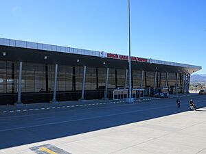
Bingöl Airport opened on July 12, 2013. This airport can handle up to 500,000 passengers each year.
Education
Bingöl University started on May 29, 2007. The university has nine faculties (like different schools), six vocational schools, and five institutes.
Notable people
Many famous people come from Bingöl, including:
- Alişan
- Abdullah Kiğılı
- Mahsun Kırmızıgül
- Servet Kocakaya
- Ali Sürmeli
- Mahmut Yıldırım
See also
 In Spanish: Bingöl para niños
 | Toni Morrison |
 | Barack Obama |
 | Martin Luther King Jr. |
 | Ralph Bunche |


