
Bird's eye view facts for kids

A bird's-eye view is a special way of looking at something from high above, just like a bird flying in the sky might see it. This type of view helps us see a lot more of an area at once, showing how different parts fit together. You can find bird's-eye views in maps, drawings, photos, and even video games. It gives you a great sense of scale and layout.
Contents
Understanding a Bird's-Eye View
A bird's-eye view shows a wide area from a very high point. Imagine you are a bird soaring far above a city. You would see buildings, roads, and parks all at once. This perspective is different from looking at something straight on. It helps us understand how things are arranged.
Why "Bird's-Eye"?
The name "bird's-eye view" comes from how birds see the world. When a bird flies high, it gets a wide, sweeping view of the ground below. This allows them to spot things like food or danger from far away. Humans adopted this term because our high-up views are similar.
How We Get These Views Today
Getting a bird's-eye view used to be very difficult. Now, technology makes it much easier.
- Airplanes and Helicopters: Flying in aircraft gives us amazing views from above.
- Drones: Small, unmanned aircraft called drones can fly high and capture photos or videos.
- Satellites: Satellites orbiting Earth take pictures of huge areas, creating detailed maps.
- Tall Buildings and Mountains: Standing on a very tall building or a high mountain also offers a natural bird's-eye view.
Uses of Bird's-Eye Views
Bird's-eye views are very useful in many different areas. They help us plan, explore, and understand our world better.
In Maps and Cartography
Maps are one of the most common places to find a bird's-eye view.
- Navigation: Maps help us find our way around cities and countries. They show roads, rivers, and landmarks from above.
- City Planning: Urban planners use these views to design new cities or improve existing ones. They can see how buildings and roads fit together.
- Geographic Information Systems (GIS): These systems use satellite images to create detailed digital maps. They help scientists study land use and environmental changes.
In Art and Photography
Artists and photographers have used bird's-eye views for centuries.
- Paintings and Drawings: Early artists created detailed cityscapes from imagined high points. These gave people a sense of what a city looked like as a whole.
- Aerial Photography: With the invention of hot air balloons and later airplanes, photographers could capture real bird's-eye images. These photos are often stunning and show familiar places in new ways.
In Video Games and Sports
Many video games use a bird's-eye perspective.
- Strategy Games: In games like "SimCity" or "Age of Empires," you control things from above. This helps you manage large areas or armies.
- Sports Broadcasts: During sports games, cameras high above the field give viewers a bird's-eye view. This helps us see plays develop and understand team strategies.
History of Bird's-Eye Views
People have always wanted to see the world from above.
- Early Maps: Some of the earliest maps, from hundreds of years ago, tried to show cities from a high perspective. These were often drawn by hand and were not always accurate.
- Hot Air Balloons: In the late 1700s, hot air balloons allowed people to actually go up and see the world from above. This was a huge step forward for creating accurate bird's-eye views.
- Kites and Pigeons: In the early 1900s, some people even attached cameras to kites or pigeons to take aerial photos!
- Modern Technology: Today, with airplanes, drones, and satellites, getting a bird's-eye view is easier and more common than ever before. It helps us explore and understand our planet in incredible detail.
Images for kids
-
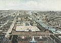
Bird's-eye view engraving of Paris in 1850
-
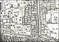
Part of the "Copperplate" map of London, surveyed between 1553 and 1559, depicting a bird's-flight view of the Moorfields area
-
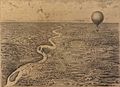
Bird's-eye view of operations during the Paraguayan War from James Allen's observation balloon, 1868
-
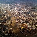
Aerial view of the City of London, 2011
-
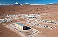
Flying above the ESO's Atacama Large Millimeter Array site
-
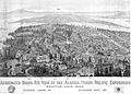
Bird's eye view wood-engraving of the Alaska-Yukon-Pacific Exposition, 1909
-
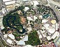
Aerial view of Disneyland in 2004
-
Painting of Schiphol Airport by the Dutch artist Janneke Viegers


See also
 In Spanish: Vista aérea para niños
