
Bloomingdale Trail facts for kids


The Bloomingdale Trail is a special elevated park in Chicago. It's about 2.7 miles long and runs from east to west on the city's northwest side. In 2015, Chicago turned an old railway line into this amazing elevated green space. This park is also known as The 606. It goes through several Chicago neighborhoods like Logan Square, Humboldt Park, and West Town.
History of the Bloomingdale Trail

The Bloomingdale Line was first built in 1873. It was a railway line used by trains. Over the years, different railroad companies owned it. Eventually, the City of Chicago bought the railway line in 2013.
Around the 1910s, the railroad was raised up about twenty feet. This was done to make it safer for people. Before, the trains ran at street level, which could be dangerous. Raising the tracks helped prevent accidents.
The railway line was used for both passenger and freight trains. It helped deliver goods to local businesses, like a Schwinn Bicycle Company warehouse. The last freight train used the line in 2001.

Today, about 3,500 trips are made on The 606 every day. Many people use it to get around the city.
From Railway to Park: The 606 Project


.jpg)


The idea of turning the Bloomingdale Line into a park started in 1997. But the line was still used by trains for a few more years. Later, in 2002-2004, the city and local communities brought the idea back. They wanted to create a long park with ramps every few blocks.
A group called "Friends of the Bloomingdale Trail" (FBT) was started in 2003. This group helped gather support for the project. They worked with the City of Chicago and a group called The Trust for Public Land. The old train tracks used to divide neighborhoods. Now, the new park helps connect them.
The Bloomingdale Trail is the longest elevated park made from an old railway line in the United States. It's also the second longest in the world!
The Chicago Department of Transportation chose a design firm in 2009. This firm would help plan and design the new park. Construction on the project began on August 27, 2013. The trail was designed with a 10-foot wide paved path. It also has a 2-foot soft shoulder on each side.
The entire park and trail system is called "The 606". This name is a nod to Chicago's ZIP Codes, which almost all start with "606". It shows how the park connects many different neighborhoods across the city.
The trail runs from Ashland Avenue all the way west to North Ridgeway Avenue. It follows West Bloomingdale Avenue, which is how it got its name. There are many entrances and exits along the trail. This makes it easy for people to walk, bike, or run on the path.
In November 2013, the Alphawood Foundation gave a $2 million grant to help pay for the trail. The park officially opened on June 6, 2015.
Images for kids
-
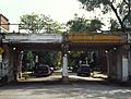
Abandoned line before renovation
.jpg)
