
Bochalema facts for kids
Quick facts for kids
Bochalema
|
|||
|---|---|---|---|
|
Municipality and town
|
|||

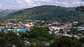
View of Bochalema
|
|||
|
|||

Location of the municipality and town of Bochalema in the Norte de Santander Department of Colombia.
|
|||
| Country | |||
| Department | Norte de Santander Department | ||
| Area | |||
| • Municipality and town | 172 km2 (66 sq mi) | ||
| Elevation | 1,051 m (3,448 ft) | ||
| Population
(2015)
|
|||
| • Municipality and town | 6,973 | ||
| • Urban | 2,509 | ||
| Time zone | UTC-5 (Colombia Standard Time) | ||
| Climate | Af | ||
.svg)

Bochalema is a town and a Colombian municipality. It is located in the Norte de Santander Department in Colombia. It's a place where many people live and work.
Contents
Where is Bochalema?
Bochalema is found in the country of Colombia. It is part of the Norte de Santander Department. You can see its exact spot on a map of Colombia. The town is located in a beautiful area.
How Big is Bochalema?
The total area of Bochalema is about 172 square kilometers. This is how much land the municipality covers. It's a good size for a town and its surrounding areas.
How Many People Live There?
In 2015, about 6,973 people lived in Bochalema. Out of these, 2,509 people lived in the main town area. The rest lived in the countryside around it.
What is the Climate Like?
Bochalema has a tropical rainforest climate. This means it is warm and rainy for most of the year. The weather helps plants and trees grow well.
How High Up is Bochalema?
Bochalema is located at an elevation of 1,051 meters above sea level. This means it's quite high up in the mountains. This elevation can affect the local weather and scenery.
Symbols of Bochalema
Like many towns, Bochalema has its own special symbols. These include a flag and a seal. They represent the history and spirit of the community.
Images for kids
-
A general view of Bochalema.
See also
 In Spanish: Bochalema para niños
