Bonita, Arizona facts for kids
Quick facts for kids
Bonita, Arizona
|
|
|---|---|

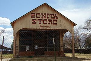
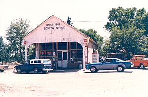
The Bonita Store in Bonita, a historic building.
|
|
| Country | United States |
| State | Arizona |
| County | Graham |
| Elevation | 4,544 ft (1,385 m) |
| Time zone | UTC-7 (Mountain (MST)) |
| Area code(s) | 928 |
| GNIS feature ID | 24330 |
Bonita is a small, unincorporated community located in Graham County, Arizona, in the United States. It is found along Arizona State Route 266. This quiet area is about 2.6 miles (4.2 km) south-southwest of Fort Grant. It is also about 22.7 miles (36.5 km) southwest of Safford, a larger town nearby.
Contents
What is an Unincorporated Community?
An unincorporated community is a place that does not have its own local government. This means it is not officially a city or a town. Instead, it is usually governed by the county it is in. For Bonita, this means Graham County helps manage things like roads and services.
Where is Bonita Located?
Bonita is nestled in the beautiful landscape of southeastern Arizona. It is part of Graham County, which is known for its mountains and desert areas. The community sits at an elevation of about 4,544 feet (1,385 meters) above sea level. This higher elevation often means cooler temperatures than the lower desert areas.
The Bonita Store
One of the most notable landmarks in Bonita is the historic Bonita Store. This building has a long history in the community. It was once a saloon and has seen many changes over the years. The store is a reminder of the past and the early days of settlement in this part of Arizona.
Nearby Places to Explore
- Fort Grant: Just a short distance from Bonita is Fort Grant. This historic site was once a U.S. Army post. It played an important role in the history of the American West. Today, it serves as a state prison.
- Safford: The city of Safford is the county seat of Graham County. It is a larger community with more services and shops. Many people from Bonita might visit Safford for supplies or other needs.
 | Bessie Coleman |
 | Spann Watson |
 | Jill E. Brown |
 | Sherman W. White |


