Bontoc, Southern Leyte facts for kids
Quick facts for kids
Bontoc
|
|||
|---|---|---|---|
| Municipality of Bontoc | |||

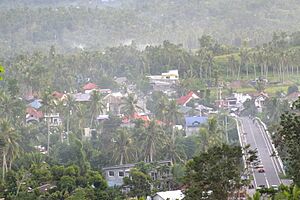
Bontoc in 2022
|
|||
|
|||

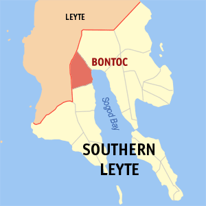
Map of Southern Leyte with Bontoc highlighted
|
|||
|
OpenStreetMap
|
|||
| Country | Philippines | ||
| Region | Eastern Visayas | ||
| Province | Southern Leyte | ||
| District | [[{{#property:P7938}} | — Lua error in Module:Wd at line 1804: attempt to index field 'wikibase' (a nil value).]] | ||
| Founded | June 15, 1950 | ||
| Barangays | 40 (see Barangays) | ||
| Government
|
|||
| • Type | Sangguniang Bayan | ||
| Area | |||
| • Total | 102.10 km2 (39.42 sq mi) | ||
| Elevation | 47 m (154 ft) | ||
| Highest elevation | 390 m (1,280 ft) | ||
| Lowest elevation | 0 m (0 ft) | ||
| Population
(2020 census)
|
|||
| • Total | 29,799 | ||
| • Density | 291.861/km2 (755.92/sq mi) | ||
| • Households | 7,283 | ||
| Economy | |||
| • Income class | 4th municipal income class | ||
| • Poverty incidence |
|
||
| • Revenue | ₱ 168.6 million (2022) | ||
| • Assets | ₱ 387.4 million (2022) | ||
| • Expenditure | ₱ 128.4 million (2022) | ||
| • Liabilities | ₱ 98.18 million (2022) | ||
| Service provider | |||
| • Electricity | Southern Leyte Electric Cooperative (SOLECO) | ||
| Time zone | UTC+8 (PST) | ||
| ZIP code |
6604
|
||
| PSGC |
[https://psa.gov.ph/classification/psgc/?q=psgc/barangays/{{#pro000®code={{&provcode=
|
||
| IDD : area code | +63 (0)53 | ||
| Native languages | Boholano dialect Cebuano Tagalog |
||
Bontoc is a town in the Philippines. It is officially known as the Municipality of Bontoc. This town is located in the province of Southern Leyte, which is part of the Eastern Visayas region.
As of the 2020 census, about 29,799 people live in Bontoc. The town is home to a campus of the Southern Leyte State University. This university offers courses in farming and industry.
Bontoc celebrates its town fiesta every year to honor the Holy Child Jesus. The Ulang Festival is a special event held on January 15. During this festival, people dance in colorful costumes to show respect for the image of the Holy Child Jesus, also known as Señor Santo Niño.
Contents
What's in a Name?
The name "Bontoc" comes from an old creek. This creek, called Bontoc Creek, is near the Roman Catholic Cemetery today. A very old town called Daan Lungsod used to be there during the early Spanish times.
A Look Back: Bontoc's History
Before the Spanish arrived, Bontoc was a wild area. Only a few native people lived there, and many wild animals roamed around. When the Spanish came, they found different groups of people. These groups lived in villages near the Salog River.
The Spanish managed to unite these groups. They created a cluster of villages that later became the Barrio of Bontoc.
Early Leaders and Spanish Rule
One of the most famous leaders from ancient times was Mariano Barcelon. People called him "Tahug." He was known as the bravest warrior. His name even scared the Moro pirates who sailed in Philippine waters in the 16th century.
During the Spanish rule and the start of American rule, Bontoc was led by native "Cabezas de barangay." These were local leaders. Bontoc was then part of the old town of Libagon. Libagon governed the people for many years.
The local leaders were also called "capitan" by their people. The church had a lot of power in the government back then. If someone upset the church, they were punished.
Some well-known "capitanes" who led Bontoc were Hilario Barcelon and Manuel Leyes. The last famous leader was Gerardo Faelnar, known as Capitan Dadoy. His leadership continued into the early American period.
American Occupation and World War II
After the Americans arrived, Bontoc became a barrio (a small district) of Sogod.
During the Japanese occupation in World War II, Bontoc was important. It became the main place for the resistance movement against the Japanese. The main headquarters was in Sitio Mamingaw, Barangay Banahaw. Colonel Ruperto K. Kangleon led this movement.
There was a famous event where a truck full of Japanese soldiers was defeated. This happened at Sitio Trece, Barangay Santo Niño. A small monument stands there today to remember this event.
On June 15, 1950, Bontoc officially became a regular municipality. This happened because of Republic Act No. 522.
Bontoc's Location and Environment
Bontoc is located on a long, flat plain. This area is known as the best farming region in the entire Sogod Bay District. The Salog and Divisoria Rivers flow through the town.
Because the soil is very rich, a lot of rice is grown here. Bontoc also produces crops like abaca, copra, and tobacco.
Local Communities: Barangays
Bontoc is divided into 40 smaller communities called barangays. Each barangay has its own smaller areas called puroks, and some also have sitios.
- Anahao
- Banahao
- Baugo
- Beniton
- Buenavista
- Bunga
- Casao
- Catmon
- Catoogan
- Cawayanan
- Dao
- Divisoria
- Esperanza
- Guinsangaan
- Hibagwan
- Hilaan
- Himakilo
- Hitawos
- Lanao
- Lawgawan
- Mahayahay
- Malbago
- Mauylab
- Olisihan
- Paku
- Pamahawan
- Pamigsian
- Pangi
- Poblacion
- Pong-on
- Sampongon
- San Ramon
- San Vicente
- Santa Cruz
- Santo Niño
- Taa
- Talisay
- Taytagan
- Tuburan
- Union
Weather in Bontoc
Bontoc has a tropical climate. This means it is generally warm all year round. It also experiences a lot of rain, especially during certain months.
| Climate data for Bontoc, Southern Leyte | |||||||||||||
|---|---|---|---|---|---|---|---|---|---|---|---|---|---|
| Month | Jan | Feb | Mar | Apr | May | Jun | Jul | Aug | Sep | Oct | Nov | Dec | Year |
| Mean daily maximum °C (°F) | 28 (82) |
29 (84) |
29 (84) |
30 (86) |
30 (86) |
30 (86) |
29 (84) |
29 (84) |
29 (84) |
29 (84) |
29 (84) |
29 (84) |
29 (84) |
| Mean daily minimum °C (°F) | 22 (72) |
22 (72) |
23 (73) |
24 (75) |
25 (77) |
25 (77) |
25 (77) |
25 (77) |
25 (77) |
25 (77) |
24 (75) |
23 (73) |
24 (75) |
| Average precipitation mm (inches) | 78 (3.1) |
57 (2.2) |
84 (3.3) |
79 (3.1) |
118 (4.6) |
181 (7.1) |
178 (7.0) |
169 (6.7) |
172 (6.8) |
180 (7.1) |
174 (6.9) |
128 (5.0) |
1,598 (62.9) |
| Average rainy days | 16.7 | 13.8 | 17.3 | 18.5 | 23.2 | 26.5 | 27.1 | 26.0 | 26.4 | 27.5 | 24.6 | 21.0 | 268.6 |
| Source: Meteoblue | |||||||||||||
Population Changes Over Time
The number of people living in Bontoc has changed over the years. Here's a look at the population counts from different census periods:
How Bontoc Makes Money
Bontoc's economy relies on farming due to its rich soil. The town is classified as a 4th municipal income class. This classification helps show its economic standing among other towns in the Philippines.
| Source: Philippine Statistics Authority |
|
 | Jessica Watkins |
 | Robert Henry Lawrence Jr. |
 | Mae Jemison |
 | Sian Proctor |
 | Guion Bluford |


