Bore Sight Range and Compass Swinging Platform at Charters Towers Airfield facts for kids
The Bore Sight Range and Compass Swinging Platform are two special places at Charters Towers Airport in Charters Towers, Queensland, Australia. They were built a long time ago, between 1942 and 1943, during World War II. These sites helped make sure airplanes were ready for battle. They are also known as the Charters Towers WWII Airfield Gun Firing Range and Compass Swinging Station. They are important historical sites in Queensland.
Quick facts for kids Bore Sight Range and Compass Swinging Platform |
|
|---|---|

Compass Swinging Platform
|
|
| Location | Charters Towers Airport, Charters Towers, Charters Towers Region, Queensland, Australia |
| Design period | 1939 - 1945 (World War II) |
| Built | 1942-1943 |
| Official name: Charters Towers Airfield Bore Sight Range and Compass Swinging Platform, Charters Towers WWII Airfield Gun Firing Range and Compass Swinging Station | |
| Type | state heritage (built) |
| Designated | 14 May 2010 |
| Reference no. | 602739 |
| Significant period | 1942-1945 |
| Lua error in Module:Location_map at line 420: attempt to index field 'wikibase' (a nil value). | |
Contents
Why Was This Airfield Built?
The Charters Towers Airfield was built in early 1942 for the United States Army. It was a backup air base for Townsville, in case Townsville was attacked by Japanese planes during World War II.
In 1942, a US bomber group used Charters Towers to launch attacks. From 1943, it became a training center for US aircraft. The Bore Sight Range and Compass Swinging Platform were built then.
How Did the War Affect Australia?
On December 7, 1941, Japan attacked the US naval base at Pearl Harbor. Soon after, Japanese forces attacked other countries. This made people in Australia worried about attacks on their own land.
Charters Towers was chosen because it was inland. This made it safer from Japanese attacks than coastal cities like Townsville. It could support the main air base in Townsville.
Building the Airfield Fast
Work on the Charters Towers airfield started quickly in January 1942. The goal was to build runways very fast. Hundreds of workers and machines were brought in. The first runway was finished in just 17 days!
To keep the airfield a secret from Japanese planes, houses nearby were used to house workers. This helped them blend in.
Planes Arrive
By March 1942, the airfield was ready. US Army Air Force planes arrived, including dive bombers and medium bombers. These planes were used for attacks against Japanese bases.
The US Army paid for the runways, taxiways, and buildings. Local mine waste was even used for the runways. This led to a funny news report that they were "paved with gold."
Improving Warplanes
Charters Towers airfield was important for making planes better. Engineers experimented with adding more powerful machine guns to planes. This made them much better for low-level attacks on ships and ground targets. This new design was used by the US in all parts of World War II.
After November 1942, Charters Towers became a training center. Pilots learned how to fly and fight there.
Building the Testing Sites
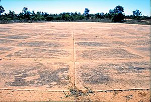
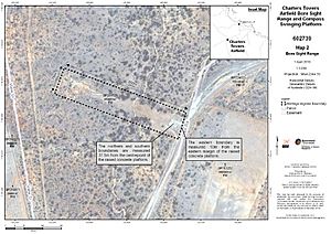
In early 1943, the US Army asked for a gun firing range, or bore sight range. This was to check how accurate airplane guns were. A concrete platform was built for this. It had a special adjustable plate for different types of planes. A steel frame helped lift the tails of other planes. The range stretched about 360 meters to an earth mound, where targets were set up.
Around the same time, a compass swinging station was built. This was a large circular concrete slab, about 36.7 meters wide. It had a compass rose drawn on it. Planes were pushed onto the platform and lined up with each compass direction. This helped adjust the plane's compass to make sure it was accurate.
In May 1944, the Royal Australian Air Force (RAAF) took over the airfield. The US forces left in December 1944. Today, the airfield is run by the Charters Towers Regional Council.
What Are These Places Like Today?
The Charters Towers Airfield is now the Charters Towers Airport. It is on the edge of Charters Towers.
The Bore Sight Range
The Bore Sight Range is a concrete platform, about 15 meters square. It has a metal plate that can be moved up or down. This plate held the front wheel of planes. A long, clear area stretches about 360 meters from the platform to an earth mound. This is where targets were placed.
The Compass Swinging Platform
The Compass Swinging Platform is about 850 meters from the Bore Sight Range. It is a large, round concrete slab. It is about 36.7 meters across. You can still see the compass directions drawn on its surface.
Why Are They Important?
The Bore Sight Range and Compass Swinging Platform are listed as important historical sites. They show how Queensland helped during World War II.
- They show how history unfolded: These sites are proof of a big US Air Force training center in Queensland during World War II. They were key to the air war in the South West Pacific.
- They are rare: The Bore Sight Range is the only one known in Queensland with an adjustable platform for different planes.
- They show their original purpose: Both sites are still mostly complete. They clearly show what they were used for. The bore sight range still has its platform and earth mound. The compass swinging platform still has its round concrete slab and compass markings.
 | Leon Lynch |
 | Milton P. Webster |
 | Ferdinand Smith |


