
Bowning facts for kids
Quick facts for kids BowningNew South Wales |
|||||||||||||||
|---|---|---|---|---|---|---|---|---|---|---|---|---|---|---|---|

Entering Bowning
|
|||||||||||||||

Bowning
Location in New South Wales
|
|||||||||||||||
| Postcode(s) | 2582 | ||||||||||||||
| Elevation | 602 m (1,975 ft) | ||||||||||||||
| Location | |||||||||||||||
| LGA(s) | Yass Valley Shire | ||||||||||||||
| State electorate(s) | Goulburn | ||||||||||||||
| Federal Division(s) | Eden-Monaro | ||||||||||||||
|
|||||||||||||||
Bowning is a small town in the South West Slopes region of New South Wales, Australia. It is about 14 kilometers (9 miles) west of Yass. The town is located along the Hume Highway, a major road connecting Sydney and Melbourne. Bowning is part of the Yass Valley Shire.
The name "Bowning" comes from an Aboriginal word. It means 'big hill'. In 2016, a census showed that Bowning and its nearby areas had a population of 573 people.
Contents
Exploring Bowning's History
Bowning is a place with a long history. It was one of the very first settlements in its area.
Bowning Hill and Early Explorers
Near the town is Bowning Hill, which stands 796 meters (2,612 feet) above sea level. Two famous explorers, Hume and Hovell, wrote about this hill in their travel journals way back in 1824.
Historic Buildings to See
Bowning has some interesting old buildings. One is the Troopers Cottage, found on the Binalong Road. Another important building is the old Cobb and Co Coaching Station. This station is on Bogolong Street and was built between 1850 and 1870. Cobb and Co were famous for their horse-drawn coaches that carried mail and passengers across Australia.
The first local school in Bowning was also very old. It was set up in 1849. This made it one of the earliest schools in inland New South Wales. The original school building has since been replaced.
The Railway's Role in Bowning
Bowning Railway Station
Bowning railway station is located on the Main South railway line. This railway line connects Sydney to Albury. The station first opened in 1876. It had two platforms where trains could stop.
The station was closed in 1992. However, many parts of the building are still there. The main station building has two stories and is now used as a local craft shop.
Heritage-Listed Sites
Bowning has some places that are officially recognized for their historical importance. These are called heritage-listed sites.
- Main Southern railway: Bowning railway station
Gallery
-
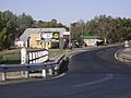
Part of Bowning township.
-
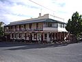
The Commercial Hotel.


