Boyds Creek, Tennessee facts for kids
Quick facts for kids
Boyds Creek
|
|
|---|---|

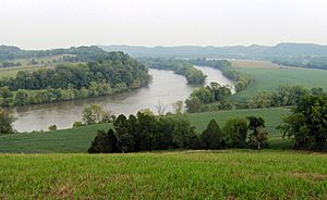
The French Broad River and rural fringe in Boyds Creek
|
|
| Country | United States |
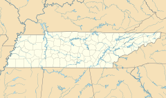
| State | Tennessee |
| County | Sevier |
| Elevation | 899 ft (274 m) |
| Time zone | UTC-5 (Eastern (EST)) |
| • Summer (DST) | UTC-4 (EDT) |
| ZIP codes |
37862, 37876
|
| GNIS feature ID | 1314721 |
Boyds Creek is a small place in Sevier County, Tennessee, in the United States. It's called an unincorporated community. This means it's a group of homes and businesses that isn't officially a city or town with its own local government.
The community gets its name from a small stream, also called Boyds Creek. This stream flows south into the French Broad River. The creek itself was named after a trader named Boyd. He was involved in an important event near the creek long ago.
Boyds Creek was also the location of an important historical event. In 1780, a battle took place here. This battle, known as the Battle of Boyd's Creek, was between early settlers and the Cherokee people. The Cherokee were upset because settlers were moving onto their traditional hunting lands.
Geography of Boyds Creek
Boyds Creek is located in a beautiful part of Tennessee. The land here is about 899 feet (or 274 meters) above sea level. This elevation gives the area a nice view of the surrounding landscape. The small Boyds Creek flows through the area, eventually joining the larger French Broad River.
 | Mary Eliza Mahoney |
 | Susie King Taylor |
 | Ida Gray |
 | Eliza Ann Grier |


