Bremond, Texas facts for kids
Quick facts for kids
Bremond, Texas
|
|
|---|---|

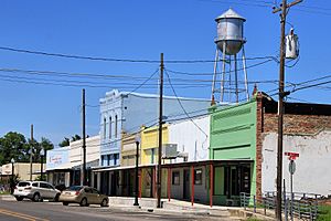
Downtown Bremond (2015)
|
|
| Country | United States |
| State | Texas |
| County | Robertson |
| Area | |
| • Total | 0.89 sq mi (2.29 km2) |
| • Land | 0.89 sq mi (2.29 km2) |
| • Water | 0.00 sq mi (0.00 km2) |
| Elevation | 459 ft (140 m) |
| Population
(2020)
|
|
| • Total | 858 |
| • Density | 1,090.29/sq mi (421.02/km2) |
| Time zone | UTC-6 (Central (CST)) |
| • Summer (DST) | UTC-5 (CDT) |
| ZIP code |
76629
|
| Area code(s) | 254 |
| FIPS code | 48-10144 |
| GNIS feature ID | 2409900 |
Bremond is a city in Robertson County, Texas, United States. In 2020, about 858 people lived there.
Contents
History of Bremond
Bremond got its name from Paul Bremond (1810–1885). He was a businessman who started the Houston, East and West Texas Railroad in 1875. Paul Bremond owned the land where the city now stands. Later, a rich cotton farmer named William Marsh Rice became the owner. His first wife was Paul Bremond's daughter, Margaret. Rice had the town mapped out and named it after Bremond. The town officially became a city in 1870.
Polish Heritage
In the 1870s, many Polish immigrants moved to the Bremond area. They came to grow cotton. Today, Bremond celebrates its Polish heritage with a festival every year.
Wootan Wells Resort
In 1878, a local person named Francis Marion Wootan found that the water in the area had many minerals. At that time, people believed mineral water could help them feel better. So, Wootan started bottling the water and selling it. Soon, a place called Wootan Wells became a popular resort. It had four hotels and many workers.
Challenges and Changes
In 1916, a big fire badly damaged the community, including Wootan Wells. Flooding and dry weather also caused problems for the town. In 1921, another fire completely shut down Wootan Wells.
Over time, the main road, Texas Highway 6, used to go through Bremond. It would join with Texas Highway 14 and then make a sharp turn. Later, Highway 6 was changed to go around Bremond, bypassing the city to the west. If you look closely today, you can still see parts of the old road's curve near where Highway 6 meets Farm to Market Road 46.
Geography of Bremond
Bremond covers an area of about 0.9 square miles (2.29 square kilometers). All of this area is land.
People of Bremond (Demographics)
| Historical population | |||
|---|---|---|---|
| Census | Pop. | %± | |
| 1880 | 758 | — | |
| 1890 | 387 | −48.9% | |
| 1940 | 1,106 | — | |
| 1950 | 1,141 | 3.2% | |
| 1960 | 803 | −29.6% | |
| 1970 | 822 | 2.4% | |
| 1980 | 1,025 | 24.7% | |
| 1990 | 1,110 | 8.3% | |
| 2000 | 876 | −21.1% | |
| 2010 | 929 | 6.1% | |
| 2020 | 858 | −7.6% | |
| U.S. Decennial Census | |||
Bremond is part of the larger Bryan-College Station metropolitan area. This means it's part of a group of cities and towns that are connected.
In 2020, there were 858 people living in Bremond. These people lived in 452 homes, and 217 of these were families.
| Race | Number | Percentage |
|---|---|---|
| White (NH) | 566 | 65.97% |
| Black or African American (NH) | 173 | 20.16% |
| Asian (NH) | 13 | 1.52% |
| Some Other Race (NH) | 1 | 0.12% |
| Mixed/Multi-Racial (NH) | 39 | 4.55% |
| Hispanic or Latino | 66 | 7.69% |
| Total | 858 |
Education in Bremond
The Bremond Independent School District serves the city of Bremond. The school's mascot is a Tiger. In the 2018–2019 school year, there were 487 students enrolled. About 35% of students were considered at risk of dropping out of school. Also, 3.5% of students were learning English as a second language.
See also
 In Spanish: Bremond (Texas) para niños
 | Lonnie Johnson |
 | Granville Woods |
 | Lewis Howard Latimer |
 | James West |

