
Brumado facts for kids
Quick facts for kids
Brumado
|
|||
|---|---|---|---|
|
Municipality
|
|||
| The Municipality of Brumado | |||

Image of the center and neighborhood of São Félix.
|
|||
|
|||
| Nickname(s):
Capital do minério,
Brumas, BDO |
|||

Location of Brumado
|
|||

Brumado
Location in Brazil
|
|||
| Country | |||
| Region | Northeast | ||
| State | Bahia | ||
| Mesoregion | Mesoregion of south central Bahia | ||
| Microregion | Microregion of Brumado | ||
| Municipal subdivisions - districts | Ubiraçaba; Itaquaraí; Cristalândia |
||
| Founded | June 11, 1877 | ||
| Area | |||
| • Municipality | 2,207.612 km2 (852.364 sq mi) | ||
| • Urban | 2,174 km2 (839 sq mi) | ||
| Elevation | 454 m (1,490 ft) | ||
| Population
(2016)
|
|||
| • Municipality | 69 473 | ||
| • Density | 29,01/km2 (7,510/sq mi) | ||
| Time zone | UTC-3 (Brasilia Official Time) | ||
| • Summer (DST) | UTC-2 (Brazilian Daylight Saving Time) | ||
| Postal Code |
46100-000
|
||
| Area code(s) | +55 77 | ||
| Website | oficial website | ||
.jpg)

Brumado is a city in Brazil. It is located in the state of Bahia. This city is in the Northeast part of the country. In 2016, about 69,473 people lived there.
Contents
What is Brumado?
Brumado is a municipality in Brazil. A municipality is like a city or town with its own local government. It is often called Capital do minério, which means "Mineral Capital." This nickname tells us something important about the city.
Where is Brumado Located?
Brumado is in the interior of the state of Bahia. Bahia is a large state in the Northeast Region of Brazil. The city is part of the Mesoregion of South Central Bahia. It is also in the Microregion of Brumado. The city sits at an elevation of 454 meters (about 1,490 feet) above sea level.
People and Life in Brumado
As of 2016, nearly 70,000 people call Brumado home. The city covers a total area of about 2,207 square kilometers. This makes it a fairly large area. The population density is about 29 people per square kilometer.
The city is led by a Mayor. The mayor helps manage the city and its services. Brumado is divided into several smaller areas called districts. These include Ubiraçaba, Itaquaraí, and Cristalândia.
Brumado's History and Economy
Brumado was officially founded on June 11, 1877. It has a rich history. The nickname "Mineral Capital" comes from its important mining industry. The area is known for its minerals. This industry has played a big role in the city's growth.
Nature and Surroundings
Brumado is surrounded by interesting natural features. The Rio do Antônio (River of the Antônio) flows nearby. There is also the Barragem de Cristalândia, which is a dam. These natural spots are important for the local environment. You can find unique plants like the Umbuzeiro tree here. This tree produces the umbu fruit. Animals like the Caatinga deer also live in the region.
Interesting Places to See
Brumado has some historical buildings. The Old City Hall is one example. The old train station is another important landmark. These places show the city's past. The Mother Church is also a significant building in the city center. The Armindo Azevedo Square is a busy area downtown. It has banks and commercial streets.
Images for kids
-
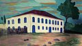
The Sobrado do Brejo (painting by Alessandro Silva) was a 19th-century mansion. It was located in the Serra das Éguas in Brumado. It was the residence of the gentlemen colonels (the lords of Sobrado do Brejo). Today, it belongs to Magnesita. -
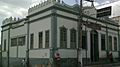
Old City Hall. -
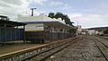
Old train station. -
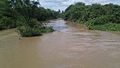
River of the Antônio, Brumado. -
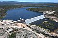
The dam of Cristalândia. -
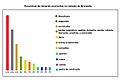
Graph of occurrences of minerals in Serra das Éguas. -
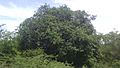
Umbuzeiro, tree of the umbu fruit. -
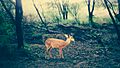
Deer of Caatinga. -
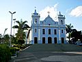
Mother church. -
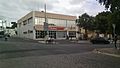
Bradesco Bank In the Armindo Azevedo Square, downtown. -
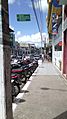
Commercial street in Brumado.


See also
 In Spanish: Brumado para niños
