Buckland Rings facts for kids

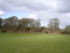
Southern ramparts of Buckland Rings
|
|
| Location | Lymington, Hampshire |
|---|---|
| Coordinates | 50°46′13″N 1°33′19″W / 50.77022°N 1.55525°W |
| Type | Hillfort |
| Area | 2.8 hectares |
| Height | 2.4 metres |
| History | |
| Periods | Iron Age |
| Site notes | |
| Excavation dates | 1935 |
| Archaeologists | Christopher Hawkes |
| Condition | Damaged on the east and west sides |
| Ownership | Hampshire County Council |
| Public access | Yes |
Buckland Rings is an amazing ancient site from the Iron Age. It's located in Lymington, Hampshire, and it used to be a strong fort. Today, you can still see the big mounds and ditches that were once its defenses. These parts are called ramparts and dykes.
Some parts of the fort have changed over time. For example, a road now covers the outer bank on the west side. Also, farming in the past flattened some areas on the south-east. In 1935, archaeologists dug up parts of the fort. They found that the inner and middle walls were built with wood and layers of turf. The main entrance, which is on the east side, was also explored. They found a long path and holes where big wooden gateposts once stood.
In 1989, Hampshire County Council bought the site to protect it. Now, Buckland Rings is open for everyone to visit.
Contents
What is Buckland Rings?
Buckland Rings is a special kind of ancient camp from the Iron Age. It has three layers of banks and ditches, and it's shaped like a rectangle. Even though it's called a "hillfort," it's actually only 27 meters (about 88 feet) above sea-level. This makes it quite rare because most hillforts are on high ground.
It's one of the best-preserved and most important sites of its kind in the Hampshire/Dorset area. The fort sits on a gravel ridge and covers about 2.8 hectares (that's like 7 football fields!). The innermost bank is 2.4 meters (almost 8 feet) tall. The middle bank is not as tall but is unusually wide.
How We Learned About It
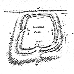
The first person to write about Buckland Rings was Thomas Wright. He visited the site in 1743. He said it was "very strong" with "double ditches, and triple Vallums" (meaning banks). Wright also drew a map of the fort, which is super helpful today. This is because some of the eastern banks were flattened by a farmer around 1750.
Wright also noticed another smaller camp nearby called Ampress Camp. For a while, some people thought Buckland Rings was a Roman camp. But in 1885, a group called the Hampshire Field Club and Archaeological Society studied the site. They decided it was not Roman and made sure that word was removed from maps.
Digging Up the Past (1935 Excavations)
The only major archaeological dig at Buckland Rings happened in 1935. It was led by a famous archaeologist named Christopher Hawkes. The team worked for three weeks, focusing on the entrance and the inner and middle banks. They looked especially at the east side, where the banks had been mostly removed in the 1700s.
Inner Ditch and Bank
The inner ditch was shaped like a "V" and was about 3.5 meters (11.5 feet) deep and 8.8 meters (29 feet) wide. Archaeologists found holes where tall wooden posts once stood at the front of the inner bank. These posts probably held up a wooden wall, keeping the bank strong. The bank itself was made from sand and gravel dug from the ditches, along with layers of cut turf.
Middle Bank
The middle bank was not as tall as the inner one. It also seemed to have been built with wooden posts and turf, similar to the inner bank.
The Entrance
The main entrance was a narrow path, about 60 meters (nearly 200 feet) long. It started from the outer ditch and led to the gates inside. The path was about 8 to 12 meters wide for most of its length. Then, it narrowed down to about 3 to 3.5 meters (10-11.5 feet) right at the gates. The gates themselves were held up by huge wooden posts, which sat in two large holes, each 90 centimeters (about 3 feet) across.
What We Learned
Not many objects were found during the excavation. They found a small iron chain, some pieces of Iron Age pottery, and a bronze tube. This tube might have been a "horn-cap," which was sometimes put on the ends of chariot yokes.
Christopher Hawkes thought the fort was built around 100 BC and was taken down around 43 AD, possibly by the Romans. However, new discoveries in archaeology since the 1930s suggest a longer history for the site. Buckland Rings might have been built much earlier, perhaps around the 5th century BC. It might have started with just one bank and ditch. Later, more banks were added. Many hillforts in southern England were no longer used before the Romans arrived, so Buckland Rings might have been abandoned by the 1st century BC. The items found during the dig are now kept in Winchester.
Looking Inside (1993 Survey)
In 1993, a special survey was done inside Buckland Rings using magnetometry. This is a way to find hidden things underground using magnetic fields. However, the ground conditions at Buckland Rings made it hard to find small features like postholes. Still, the survey helped map out where the missing defenses were and confirmed the location of Hawkes's earlier digs. It also helped define parts of the entrance. But it wasn't clear if there were signs of homes or other settlement activities inside the fort.
Buckland Rings Today
Today, Buckland Rings is very well preserved. The most obvious changes are where parts of the eastern banks were flattened in the 1700s. Also, the outer bank on the west side has been partly covered by the road. A couple of houses were built inside the western part of the fort in the early 1900s.
In 1986, someone wanted to build a leisure centre inside Buckland Rings. But these plans were stopped in 1988 after a public inquiry. Since 1989, Buckland Rings has been looked after by Hampshire County Council. It is now a Scheduled Ancient Monument, which means it's a very important historical site protected by law. Visitors can walk around and explore the site. There's also a bicycle dirt jumping track nearby in an old gravel pit.
Ampress Camp
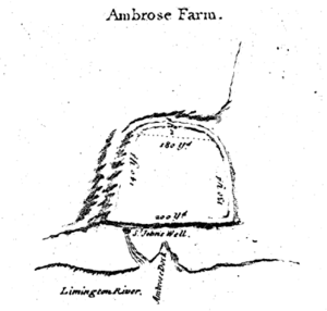
Close to Buckland Rings, there's another ancient earthwork called Ampress Camp. It's about 360 meters (1,180 feet) east of Buckland Rings, next to the Lymington River. Thomas Wright also noted Ampress Camp in 1744. He described it as being on lower ground, protected by the river on one side and a marsh on the other.
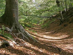
The outer bank that Wright drew has long since been flattened, and the ditches have been filled in. Today, waterworks buildings are on the northern part of the site, and other buildings have taken over the western half. However, part of the inside (the southeastern area) is still an open field. A sunken lane follows the line of the southern inner ditch for a short distance.
Only a few small digs have happened at Ampress Camp. Some pieces of pottery found there might be from the Iron Age. If both Buckland Rings and Ampress Camp are from the Iron Age, it's unusual to have two such camps so close together. Ampress Camp might have been a landing spot for people from Buckland Rings, or it could have been used during a different time in the Iron Age.
Images for kids
 | William Lucy |
 | Charles Hayes |
 | Cleveland Robinson |


