
Lymington River facts for kids
Quick facts for kids River Lymington or Lymington River |
|
|---|---|

New Forest ponies grazing next to the Lymington River near Brockenhurst
|
|

The mouth in a Hampshire outline natural map.
|
|
| Other name(s) | Highland Water |
| Country | England |
| Region | Hampshire |
| District | New Forest |
| Physical characteristics | |
| Main source | Ocknell Plain 105 metres (344 ft) 50°54′43″N 1°39′22″W / 50.912°N 1.656°W |
| River mouth | Lymington 0 metres 50°45′00″N 1°31′59″W / 50.750°N 1.533°W |
| Length | 22 km (14 mi) |
| Basin features | |
| Tributaries |
|
The Lymington River is a lovely river that flows through the New Forest in Hampshire, a county in southern England. It starts from many small streams to the west of Lyndhurst. Some of these streams are called Highland Water, Bratley Water, and Fletchers Water. From the town of Brockenhurst, the river flows south until it reaches the Solent (which is a strait of the English Channel) at Lymington.
Highland Water begins near Ocknell Inclosure and flows for about 10 km (6 mi) (6 miles) until it meets Ober Water at Bolderford Bridge. From that point, it becomes known as the Lymington River. It then travels another 12 km (7 mi) (7.5 miles) to the sea.
Contents
River History and Changes
The Lymington River has changed a lot over time, especially near its mouth.
The Old Causeway
In 1731, a sea captain named Captain Cross built a causeway and a bridge across the river's wide mouth, just north of Lymington. He even built toll houses and charged people to use his new crossing. This was more than a mile south of an older bridge at Boldre.
Captain Cross's causeway caused problems for the river. It slowed the water flow and made the Lymington harbour fill up with mud and sand much faster. This meant that larger ships could no longer use the harbour easily. The town of Lymington tried to fight this in court, but they lost their case.
Harbour Silting
By 1795, people were worried that the mud building up in the river's mouth would completely block it. They feared it would become too shallow for any big ships to sail through.
The causeway was later taken over by a railway company, which continued to collect tolls. After the railways became national (owned by the country), Hampshire County Council bought the causeway in 1955. The tolls helped pay for it and stopped a few years later.
Today, the harbour still gets muddy because of the causeway, which acts almost like a small dam. However, higher sea levels and the strong currents from the Isle of Wight ferries help to clear some of the mud away. Before the causeway was built, the daily tides from the sea could affect the river's flow all the way up to Brockenhurst.
The edge of the mud at the river's mouth at low tide is now about 550 to 650 metres closer to land than it was in 1895. This shows how much the river's shape has changed over the years.
Amazing Reedbeds
The Lymington River has many large areas of reedbeds. These are special places where tall grass-like plants called reeds grow thickly in the water. These reedbeds are so important for nature that they are protected as a Site of Special Scientific Interest. This means they are very valuable for wildlife and need to be looked after carefully.
River Water Quality
The Environment Agency checks the water quality of rivers in England. They give each river system an overall "ecological status," which tells us how healthy the river environment is. This status can be high, good, moderate, poor, or bad.
They look at different things to decide this:
- Biological status: This checks the types and numbers of living things in the water, like tiny invertebrates (animals without backbones), flowering plants, and fish.
- Chemical status: This checks if there are any harmful chemicals in the water and compares their amounts to safe levels. Chemical status is either "good" or "fail."
In 2019, the Lymington River and its main parts had a "moderate" ecological status. This means the river's environment is okay, but it could be healthier. Sadly, the chemical status for all parts of the river was a "fail." This suggests there are some chemicals in the water that are not at safe levels.
Images for kids
-
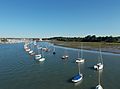
The river at its mouth, looking northwest towards the town of Lymington

