Bulbur Glacier facts for kids
Quick facts for kids Bulbur Glacier |
|
|---|---|

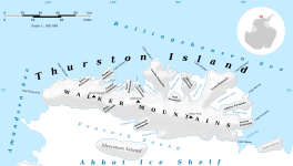
Map of Thurston Island
|
|
| Location | Ellsworth Land |
| Coordinates | 72°27′S 98°33′W / 72.450°S 98.550°W |
| Thickness | unknown |
| Terminus | O'Dowd Cove |
| Status | unknown |
Bulbur Glacier (72°27′S 98°33′W / 72.450°S 98.550°W) is a giant, slow-moving river of ice located in the very cold continent of Antarctica. Specifically, you can find it in the middle-southern part of Thurston Island. This glacier flows south, moving along the western side of some rocky areas known as Boker Rocks, until it reaches a bay called O'Dowd Cove.
What is a Glacier?
A glacier is a huge mass of ice that moves slowly over land. Imagine a very thick, frozen river! Glaciers form in places where snow falls and builds up over many years, turning into ice. They are incredibly powerful and can even shape the landscape as they creep along.
Where is Bulbur Glacier Located?
Bulbur Glacier is found on Thurston Island, which is a large, ice-covered island off the coast of Ellsworth Land in West Antarctica. This area is known for its extreme cold and vast icy landscapes. The glacier's journey ends when it reaches O'Dowd Cove, where its ice might break off into the ocean, forming icebergs.
How Did Bulbur Glacier Get Its Name?
This glacier was officially named by the Advisory Committee on Antarctic Names. It was named after a person named E.R. Bulbur. He was a Photographer's Mate in the U.S. Navy.
Bulbur was part of a special mission called U.S. Navy Operation Highjump, which took place in 1946 and 1947. During this operation, his team took many aerial photographs of Thurston Island and the nearby coastal areas. These photos were super important for mapping and understanding this remote part of Antarctica. Naming the glacier after him was a way to honor his contributions to exploring and mapping the icy continent.


