
Thurston Island facts for kids

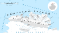
Map of Thurston Island
|
|

Thurston
Location in Antarctica
Location of Thurston Island
|
|
| Geography | |
|---|---|
| Location | Antarctica |
| Coordinates | 72°6′S 99°0′W / 72.100°S 99.000°W |
| Area | 15,700 km2 (6,100 sq mi) |
| Area rank | 56th |
| Length | 215 km (133.6 mi) |
| Width | 90 km (56 mi) |
| Highest elevation | 750 m (2,460 ft) |
| Highest point | Mount Howell |
| Administration | |
| Administered under the Antarctic Treaty System | |
Thurston Island is a large island covered in ice, located near the northwest part of Ellsworth Land in Antarctica. It is about 215 kilometers (134 miles) long and 90 kilometers (56 miles) wide, covering an area of 15,700 square kilometers (6,062 square miles). This makes it the third largest island in Antarctica, after Alexander Island and Berkner Island.
The island was first seen from the air by Rear Admiral Richard E. Byrd on February 27, 1940. He named it after W. Harris Thurston, who was a textile maker from New York. Thurston helped fund Antarctic trips and designed a special windproof fabric called "Byrd Cloth". Thurston Island is separated from the mainland by a narrow waterway called Peacock Sound. This sound is mostly covered by the western part of the Abbot Ice Shelf. Thurston Island also helps divide two large seas: the Bellingshausen Sea to its east and the Amundsen Sea to its west. For a long time, people thought Thurston Island was actually a peninsula (land connected to the mainland on one side). It wasn't until 1960 that it was finally recognized as a separate island.
Contents
What is Thurston Island like?
Thurston Island is a land of ice and mountains. The westernmost tip of the island is called Cape Flying Fish, and the easternmost point is Cape Annawan. The southeastern tip is Cape Walker.
Mountains and Glaciers
The island is split from south to north by the Walker Mountains. These are a chain of peaks and nunataks (rocky peaks that stick out above glaciers). You can also find other peaks on the Edwards Peninsula and Noville Peninsula. There are many glaciers flowing across Thurston Island, shaping its icy landscape.
Exploring the Coasts
Thurston Island has a long coastline with many interesting features.
The East Coast

The easternmost part of the island is Tierney Peninsula. To its southeast is Seraph Bay. Here, you'll find Simpson Bluff, a wide, ice-covered cliff between two glaciers, Levko Glacier and Savage Glacier, as they flow into the bay. Nearby is Baker Knob, a small, round hill by the coast with a steep eastern side. Both Simpson Bluff and Baker Knob were named by a group called US-ACAN after photographers from the U.S. Navy Operation Highjump. This operation took aerial photos of Thurston Island and nearby areas between 1946 and 1947.
Further south, you'll see Harrison Nunatak, a snow-covered peak about 4 nautical miles (7 kilometers) south of Savage Glacier. This nunatak was found during helicopter flights in February 1960 by ships from the U.S. Navy. It was named after Henry T. Harrison, Jr., a meteorologist who worked with the Byrd Antarctic Expedition in 1928–30. The very southeastern tip of the island is Cape Walker.
The South Coast
Along the southern side of Thurston Island, several peninsulas and points stick out into Peacock Sound. These include King Peninsula, Williamson Peninsula, Evans Point, and Von der Wall Point. Williamson Peninsula has two coves, Schwartz Cove and O'Dowd Cove.
Another feature is Shelton Head, a rocky point about 12 nautical miles (22 kilometers) west of Long Glacier. It was named after John A. Shelton, a meteorologist who worked at Byrd Station in 1963-64.
West of Shelton Head, you'll find Prickly Ridge, a rounded, ice-covered ridge. It got its name because small, scattered nunataks poke through the ice, making it look "prickly." The largest rock outcrop on this ridge is Belknap Nunatak. It was named after William Belknap, who was a field assistant at Byrd Station in 1964–65.
Images for kids
-
Map of Thurston Island
-
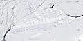
Satellite image of Thurston Island, showing its icy landscape.
See also
 In Spanish: Isla Thurston para niños
