Cape Flying Fish facts for kids
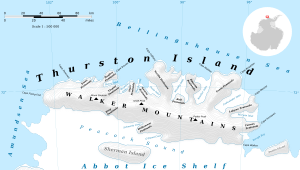
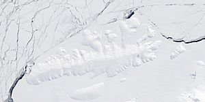
Cape Flying Fish is a special place in Antarctica. It is a cape, which is a piece of land that sticks out into the sea. This cape is covered in ice and snow. It forms the very western tip of Thurston Island. Sometimes, it is also called Cape Dart.
What is Cape Flying Fish?
Cape Flying Fish is a large, icy point of land. It is located in a very cold part of the world, Antarctica. This cape is important because it marks a boundary. It separates two large areas of the ocean. To its west is the Amundsen Sea. To its east is the Bellingshausen Sea. It also marks the end of one coastline and the start of another. It is the eastern edge of the Walgreen Coast. It is also the western edge of the Eights Coast.
How was it discovered?
Cape Flying Fish was first seen by people in February 1940. It was discovered by a famous explorer named Rear Admiral Richard E. Byrd. He was flying in an airplane from a ship called the Bear. Members of the US Antarctic Service were with him. They were exploring the icy lands of Antarctica.
Where did its name come from?
The cape was given its name by the Advisory Committee on Antarctic Names. They named it after a ship called the Flying Fish. This ship was part of the United States Exploring Expedition. That expedition happened many years before the cape was discovered. The Flying Fish was commanded by Lieutenant William M. Walker. In 1839, the ship sailed very close to where the cape is now. It came within about 125 miles of this icy point.
See also
 You can also read about Cape Flying Fish in Spanish: Cabo Pez Volador para niños
 | Anna J. Cooper |
 | Mary McLeod Bethune |
 | Lillie Mae Bradford |


