
Amundsen Sea facts for kids


The Amundsen Sea is a part of the Southern Ocean located near Antarctica. It is found off the coast of Marie Byrd Land in western Antarctica. This sea is bordered by Cape Flying Fish to the east and Cape Dart to the west. To the east of Cape Flying Fish, you'll find the Bellingshausen Sea. The Amundsen Sea was named after Roald Amundsen, a famous Norwegian explorer who explored the polar regions.
Most of the Amundsen Sea is covered by ice. The huge ice sheet that flows into this sea is about 3 kilometers (1.9 miles) thick. This ice sheet is roughly the same size as the state of Texas! This entire area is often called the Amundsen Sea Embayment (ASE). It is one of the three main areas where ice drains from the West Antarctic Ice Sheet.
Scientists have been studying the ice in the Amundsen Sea closely. In 2004, a study suggested that the ice was melting quickly and had many cracks. This meant that the ice shelf offshore might collapse within five years. If all the sea ice in the Amundsen Sea melted, it could cause global sea levels to rise by about 1.3 meters (4.3 feet).
In 2005, the British Antarctic Survey measured how much ice was flowing into the Amundsen Sea. They found that about 250 cubic kilometers (60 cubic miles) of ice were flowing into the sea each year. This amount of melting ice alone is enough to raise global sea levels by about 0.2 millimeters each year.
Scientists have also found a hidden volcano under the ice in this area. It is located near the Hudson Mountains, just north of the Pine Island Glacier. This volcano last erupted about 2,200 years ago. We know this because of ash found deep within the ice. This was the biggest known volcanic eruption in Antarctica in the last 10,000 years.
Some scientists think that this volcanic activity might be making the glaciers flow faster. However, most scientists believe that the increased ice flow is mainly due to warmer ocean water. This warmer water comes from deep in the ocean and rises to the surface. Changes in pressure systems can cause this water to rise. These changes might even be connected to global warming.
Exploring the Amundsen Sea
Pine Island Bay

Pine Island Bay is a large bay in the Amundsen Sea. It is about 40 kilometers (25 miles) long and 30 kilometers (19 miles) wide. The ice from the Pine Island Glacier flows into this bay from its southeast end. The bay was named after the ship USS Pine Island.
Russell Bay
Russell Bay is another open bay in the southwestern part of the Amundsen Sea. It stretches along the northern sides of Siple Island, the Getz Ice Shelf, and Carney Island. It goes from Pranke Island to Cape Gates. This bay was named after Admiral James S. Russell, who was a Vice Chief of Naval Operations in the U.S. Navy.
Images for kids
-
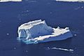
An Antarctic iceberg floating in the Amundsen Sea water, October 2009.
-
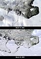
The large B-22 iceberg breaking off from Thwaites Glacier and parts of the B-21 iceberg from Pine Island Glacier in Pine Island Bay.


See also
 In Spanish: Mar de Amundsen para niños
