
Alexander Island facts for kids

Alexander Island shown within Antarctica
|
|
| Geography | |
|---|---|
| Location | Antarctica |
| Coordinates | 71°00′S 70°00′W / 71.000°S 70.000°W |
| Area | 49,070 km2 (18,950 sq mi) |
| Area rank | 28th |
| Length | 240 mi (390 km) |
| Width | 50 mi (80 km) |
| Highest elevation | 2,987 m (9,800 ft) |
| Administration | |
|
Antarctica
|
|
| Demographics | |
| Population | 0 |
Alexander Island, also known as Alexander I Island, is the largest island in Antarctica. It is located in the Bellingshausen Sea, which is west of a land area called Palmer Land. This island is separated from the main Antarctic Peninsula by Marguerite Bay and George VI Sound. George VI Sound is a body of water filled with ice. It connects Alexander Island to Palmer Land. The island also partly surrounds Wilkins Sound to its west.
Alexander Island is about 240 miles (386 km) long. It is 50 miles (80 km) wide in the north. In the south, it becomes wider, reaching about 150 miles (241 km) across. This makes Alexander Island the second largest island in the world where no one lives. The largest uninhabited island is Devon Island.
Contents
Discovering Alexander Island
Alexander Island was found on January 28, 1821. It was named after the ruler of Russia at that time, Alexander I of Russia. He was known as a Tsar, which is like a king or emperor. For many years, people thought Alexander Island was actually part of the main land of Antarctica. It was not until 1940 that scientists realized it was a separate island.
Unique Features of the Island
One interesting feature on Alexander Island is Hodgson Lake. This lake used to be hidden under a thick sheet of ice. It is what we call a subglacial lake, meaning it was once completely covered by a glacier. Now, it is no longer hidden under the ice sheet.
Hodgson Lake Details
Hodgson Lake is about 1.2 miles (2 km) long. It is also about 0.93 miles (1.5 km) wide. The water in the lake is very deep, reaching about 306 feet (93.4 meters). This deep water is sealed under a layer of lake ice. This ice layer is quite thick, usually between 12 to 13 feet (3.6 to 4.0 meters).
Images for kids
-
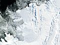
Satellite photo of Alexander Island (NASA imagery)
-
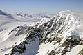
Alexander Island Mountain Ranges
-
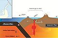
Antarctic Peninsula's tectonic movement
-
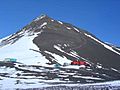
Fossil Bluff base on Alexander Island

.jpg)


See also
 In Spanish: Isla Alejandro I para niños
