Bun Sruth facts for kids
Quick facts for kids Bun Sruth |
|
|---|---|

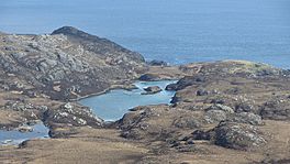
The loch of Bun Sruth
|
|
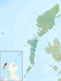
| Location | South Uist Scotland |
| Coordinates | 57°06′41″N 7°13′08″W / 57.1115°N 7.2189°W |
| Type | loch |
| Max. length | 70 yards (64 m) |
Bun Sruth is a small, hidden loch (a Scottish word for a lake) located on the island of South Uist in Scotland. This beautiful loch is about 70 yards (64 m) long. It sits at the very southeast end of the island, surrounded by tall hills. Bun Sruth is special because it connects to the sea through a narrow passage between steep cliffs. Its name means "Bottom of the stream," which makes sense when you see how it's tucked away!
Contents
Exploring Bun Sruth
Bun Sruth is a bit of a secret spot, and getting there can be an adventure!
How to Reach the Loch
You can only get to Bun Sruth by walking or by boat. There are no roads leading directly to it. This makes it a quiet and peaceful place.
Boating Challenges
If you try to reach Bun Sruth by boat from the sea, it can be tricky. The narrow passage, called a gorge, is hard to spot. The water flow can be very fast due to the tides. Also, lots of seaweed can get tangled in boat propellers.
At low tide, the water level inside the loch is higher than the sea. This means the water drains out over a rocky shelf. Because of this, boats cannot enter until the tide has risen quite a bit, at least seven feet. The best time to leave by boat is right after high tide.
Wildlife at Bun Sruth
Even though there are some old house ruins nearby, the area around Bun Sruth is now mostly home to animals.
Animals You Might See
You'll mostly find sheep grazing in the valley. The loch itself is home to different kinds of fish.
Fish in the Loch
- Pollock are often found swimming in the loch.
- Sea trout have been seen here.
- Salmon have also been reported in the waters.
Sometimes, fishing boats use the loch as a safe place to shelter from storms.
Images for kids


