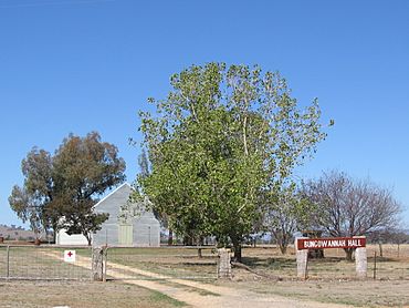
Bungowannah facts for kids
Quick facts for kids BungowannahNew South Wales |
|
|---|---|

Community Hall
|
|
| Postcode(s) | 2640 |
| Location | |
| LGA(s) | Greater Hume Shire |
| Region | Riverina |
| County | Hume |
| State electorate(s) | Albury |
Bungowannah is a small place, or locality, located in the Riverina region of New South Wales, Australia. It's like a small neighborhood or community within a larger area. You can find Bungowannah along the Riverina Highway. It's about 16 kilometers (10 miles) north-west of a bigger town called Albury. It's also about 8 kilometers (5 miles) south-east of Howlong.
What is Bungowannah?
Bungowannah is part of the beautiful Riverina region. This area is known for its wide-open spaces and farming. Even though it's a small place, it has its own history.
A Look at Bungowannah's Past
One interesting part of Bungowannah's history involves its old Post Office. A post office is a place where people send and receive mail.
- The Bungowannah Post Office first opened a long time ago, on December 1, 1867.
- It closed for a while between 1906 and 1918.
- Then, it opened again for some years.
- Finally, it closed for good in 1951.
This shows how communities change over time. When a post office closes, it often means that fewer people live in the area, or they use other ways to send mail.
What's the Weather Like in Bungowannah?
Bungowannah experiences a climate typical of the Riverina region. This usually means warm to hot summers and cool winters. The area gets a fair amount of rain throughout the year, which is important for the local farms.


