
Cáchira facts for kids
Quick facts for kids
Cáchira
|
||
|---|---|---|
|
Municipality and town
|
||

View of Cáchira and surrounding mountains
|
||
|
||

Location of Cáchira in Norte de Santander
|
||

Cáchira
Location in Colombia
|
||
| Country | ||
| Department | Norte de Santander Department | |
| Subregion | Western | |
| Founded | 7 March 1811 | |
| Area | ||
| • Municipality and town | 605.94 km2 (233.95 sq mi) | |
| Elevation | 2,025 m (6,644 ft) | |
| Population
(2015)
|
||
| • Municipality and town | 10,970 | |
| • Density | 18.104/km2 (46.889/sq mi) | |
| • Urban | 1,700 | |
| Time zone | UTC-5 (Colombia Standard Time) | |
| Climate | Cfb | |
.svg)
Cáchira is a town and municipality in Colombia. It is located in the Norte de Santander Department. The town sits high up in the Andes Mountains, about 2,025 meters (6,644 feet) above sea level. It's part of the Eastern Ranges of the Colombian Andes.
Contents
Climate and Weather in Cáchira
Cáchira has a cool and mild climate, which is called an oceanic climate (Cfb). This means it doesn't get too hot or too cold. The average temperature throughout the year is around 17 degrees Celsius (63 degrees Fahrenheit).
Temperatures and Rainfall
The warmest months are usually February and May, with average high temperatures around 22.8 degrees Celsius (73 degrees Fahrenheit). The coolest months are November and December, with average highs around 21.4 to 22.0 degrees Celsius (70-72 degrees Fahrenheit).
Cáchira receives a good amount of rain, especially from April to October. September and October are the wettest months, with over 140 millimeters (5.5 inches) of rain each. The driest months are January and February.
Sunny Days and Humidity
Even with the rain, Cáchira gets a fair amount of sunshine. January is often the sunniest month. The air is quite humid throughout the year, usually around 86%. This humidity helps keep the plant life lush and green.
Exploring Cáchira's Nature
Cáchira is known for its beautiful natural landscapes. High up in the mountains, you can find unique ecosystems called páramos. These are special areas with cool, misty weather and unique plants.
The Seven Lakes of Cáchira
One famous spot is "Siete Lagunas," which means "Seven Lakes." These lakes are located in the páramo area of Cáchira. They are a beautiful example of the natural wonders you can find there.
Unique Plants: The Frailejón
In the páramo areas, you can also see special plants like the Espeletia schultzii, often called frailejón. These plants are very important for the ecosystem. They help collect water from the misty air, which then flows into rivers and streams.
Images for kids
-
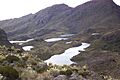
Siete Lagunas ("Seven Lakes") on Cáchira's páramo
-
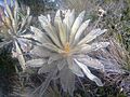
Espeletia schultzii on Cáchira's páramo


See also
 In Spanish: Cáchira para niños
