
Cúa facts for kids
Quick facts for kids
Cúa
Nuestra Señora del Rosario de Cúa
|
|||
|---|---|---|---|

Our Lady of the Rosary of Cúa Church
|
|||
|
|||
| Nickname(s):
The Tuy Pearl
|
|||
.svg)
Cúa
Location in Venezuela
|
|||
| Country | |||
| State | Miranda | ||
| Municipality | Urdaneta | ||
| Area | |||
| • Total | 273 km2 (105 sq mi) | ||
| Elevation | 490 m (1,610 ft) | ||
| Population
(July 1, 2009)
|
|||
| • Total | 127,900 | ||
| • Density | 468.50/km2 (1,213.4/sq mi) | ||
| Climate | Aw | ||
| Website | Urdaneta Municipality website | ||


Cúa is a small city in northern Venezuela. It was founded in 1690 and is the capital of the Urdaneta Municipality in Miranda State. Cúa is about 490 meters (1,600 feet) above sea level.
The city is known for its warm and sunny weather all year round. It gets about 60 days of rain each year. Temperatures usually range from 18°C to 28°C (64°F to 82°F). The air is not very humid.
Cúa has many green forests and open fields. About 123,000 people lived there in 2004. Most people work in services or industry, like making plastic pipes and paper rolls. Cúa is often called a "dormitory town" because many people live there but work in nearby larger cities.
Some important areas in Cúa include Nueva Cúa, Lecumberry, La Fila, Mume, Santa Rosa, and Aparay.
The local church, called the Sanctuary of the Virgin of Betania, is famous. Many people believe that Mary, the mother of Jesus, has appeared there.
Cúa is also connected to other places by the IFE Ezequiel Zamora train system.
Contents
History of Cúa
The first people to live in the Cúa area were the Quiriquire natives. This was long before Europeans arrived. Cúa is nicknamed The Tuy Pearl because it is located along the Tuy River.
The city was officially founded on October 6, 1690. A friar named Manuel de Alesson started the town. It was named after Our Lady of the Rosary. People moved to Cúa from different areas because the valley had very fertile land. It was also in a good location for farming.
Before this, a first village was started in 1633 in a place called Marín. However, a strong earthquake destroyed this village completely. The earthquake affected much of the Tuy Valleys.
The name Cúa has a few possible origins:
- Some historians say it comes from the Cumanagotos natives. In their Carib language, "Cúa" means "Crab." This would mean Cúa is a place where many crabs live.
- Others believe the name comes from Apacuana. She was a brave native woman from the area who fought against the Spaniards.
- Another idea is that the name honors a native ally of the Spaniards named Cue. He helped to found and build the town.
Cúa's Climate
| Month | Jan | Feb | Mar | Apr | May | Jun | Jul | Aug | Sep | Oct | Nov | Dec | Year |
|---|---|---|---|---|---|---|---|---|---|---|---|---|---|
| Mean daily maximum °C (°F) | 30.8 (87.4) |
32.0 (89.6) |
33.4 (92.1) |
34.3 (93.7) |
33.6 (92.5) |
32.1 (89.8) |
31.4 (88.5) |
31.9 (89.4) |
32.7 (90.9) |
32.8 (91.0) |
32.3 (90.1) |
30.8 (87.4) |
32.3 (90.2) |
| Daily mean °C (°F) | 24.7 (76.5) |
25.5 (77.9) |
26.8 (80.2) |
27.9 (82.2) |
27.9 (82.2) |
27.0 (80.6) |
26.4 (79.5) |
26.5 (79.7) |
27.0 (80.6) |
27.0 (80.6) |
26.6 (79.9) |
25.2 (77.4) |
26.5 (79.8) |
| Mean daily minimum °C (°F) | 18.6 (65.5) |
19.0 (66.2) |
20.1 (68.2) |
21.5 (70.7) |
22.2 (72.0) |
22.0 (71.6) |
21.4 (70.5) |
21.2 (70.2) |
21.3 (70.3) |
21.2 (70.2) |
20.8 (69.4) |
19.5 (67.1) |
20.7 (69.3) |
| Average relative humidity (%) | 68.8 | 68.1 | 65.9 | 66.3 | 68.7 | 70.9 | 72.3 | 71.5 | 69.7 | 69.6 | 70.4 | 69.5 | 69.3 |
| Source: Instituto Nacional de Meteorología e Hidrología (INAMEH) | |||||||||||||
Cúa's Population and Area
Cúa covers an area of 273 square kilometers (about 105 square miles). In 2004, its population was around 123,000 people.
The city borders different municipalities:
- To the north: Cristóbal Rojas (Charallave) and Guaicaipuro (Paracotos parish).
- To the south: San Casimiro municipality in Aragua state.
- To the east: Tomás Lander municipality (Santa Bárbara and Ocumare del Tuy parishes).
- To the west: Guaicaipuro municipality (Tácata parish).
Main roads connect Cúa to other cities. The Charallave-Cúa highway links it to the rest of the Tuy Valleys and Caracas. There are also connections to the Regional del Centro Freeway and roads leading to the Venezuelan plains, Ocumare, and Tácata.
Areas within Cúa
Cúa is divided into several districts:
- Las Brisas
- La Morita
- Lecumberry
- La Magdalena
- La Fila
- Pueblo Nuevo
- Mume
- Santa Rosa
- La Vega
- Quebrada de Cúa
- Los Rosales
- Las Mercedes
- San Antonio de Cúa
- La Mata
- Terrazas de Cúa
- Santa Cruz
- Aparay
- Nueva Cúa
- Petarito
- Sutil
- San Miguel
- Portachuelos
- Aragüita
- Marín
Cúa's Parishes
The city is also divided into two parishes:
- Cúa
- Nueva Cúa
Getting Around Cúa
Buses are the main way people travel around Cúa. Different companies operate these buses on the city's streets and avenues.
- Bus: These are large buses.
- Buseta: These are medium-sized buses.
- Microbus or Colectivo: These are smaller vans or minivans.
The IFE train also offers services. You can take the train to and from Caracas and Charallave.
Main Streets and Avenues
Some of the important streets and avenues in Cúa include:
- Perimetral avenue
- Monseñor Pellín avenue
- José María Carreño street
- El Rosario street
- El Carmen street
- Lecumberry street
- San Rafael street
- Juan España street
- Zamora street
Famous People from Cúa
Many notable people have come from Cúa, including:
- Ezequiel Zamora
- José María Carreño
- Cristóbal Rojas
- Baudilio Díaz
- María Teresa Castillo
- Victor Guillermo Ramos Rangel
- Evencio Castellanos
- Pancho Prin
- Gregor Blanco
Images for kids
-
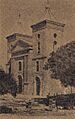
Church of Cúa, 19th century
-
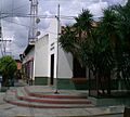
Cúa Municipal Council
-
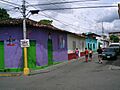
Typical street of the town
-
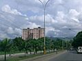
Perimetral Avenue


See also
 In Spanish: Cúa (Venezuela) para niños
