Cagayancillo facts for kids
Quick facts for kids
Cagayancillo
|
|||
|---|---|---|---|
| Municipality of Cagayancillo | |||

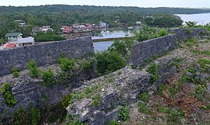
View from Cagayancillo Fort
|
|||
|
|||

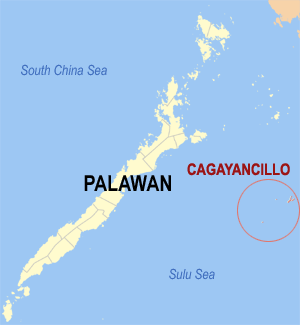
Map of Palawan with Cagayancillo highlighted
|
|||
|
OpenStreetMap
|
|||
| Country | Philippines | ||
| Region | Mimaropa | ||
| Province | Palawan | ||
| District | [[{{#property:P7938}} | — Lua error in Module:Wd at line 1804: attempt to index field 'wikibase' (a nil value).]] | ||
| Founded | 1810 | ||
| Barangays | 12 (see Barangays) | ||
| Government
|
|||
| • Type | Sangguniang Bayan | ||
| Area | |||
| • Total | 26.39 km2 (10.19 sq mi) | ||
| Elevation | 2.0 m (6.6 ft) | ||
| Highest elevation | 62 m (203 ft) | ||
| Lowest elevation | 0 m (0 ft) | ||
| Population
(2020 census)
|
|||
| • Total | 6,884 | ||
| • Density | 260.86/km2 (675.61/sq mi) | ||
| • Households | 1,367 | ||
| Economy | |||
| • Income class | 6th municipal income class | ||
| • Poverty incidence |
|
||
| • Revenue | ₱ 24.81 million (2012), 28.08 million (2013), 31.4 million (2014), 2.893 million (2015), 36.51 million (2016), 43.23 million (2017), 45.79 million (2018), 49.95 million (2019), 60.31 million (2021) | ||
| • Assets | ₱ 21.6 million (2012), 22.28 million (2013), 28.05 million (2014), 41.05 million (2015), 69.57 million (2016), 82.22 million (2017), 91.12 million (2018), 112.2 million (2019), 120.2 million (2021) | ||
| • Expenditure | ₱ 21.89 million (2012), 22.59 million (2013), 23.17 million (2014), 27.17 million (2015), 31.92 million (2016), 32.61 million (2017), 34.83 million (2018), 40.91 million (2019), 51.99 million (2021) | ||
| • Liabilities | ₱ 7.906 million (2012), 7.559 million (2013), 7.178 million (2014), 10.94 million (2015), 22.65 million (2016), 24.7 million (2017), 22.72 million (2018), 38.9 million (2019), 27.49 million (2021) | ||
| Service provider | |||
| • Electricity | Palawan Electric Cooperative (PALECO) | ||
| Time zone | UTC+8 (PST) | ||
| ZIP code |
5321
|
||
| PSGC |
[https://psa.gov.ph/classification/psgc/?q=psgc/barangays/{{#pro000®code={{&provcode=
|
||
| IDD : area code | +63 (0)48 | ||
| Native languages | Kagayanen Palawano Tagalog |
||
Cagayancillo is a small group of islands in the Sulu Sea, part of the Palawan province in the Philippines. Its full name is the Municipality of Cagayancillo. In 2020, about 6,884 people lived there. The name "Cagayancillo" means "Little Cagayan" in Spanish.
These islands are located between Palawan and Negros. They are the closest land to the famous Tubbataha National Marine Park, a protected area known for its amazing marine life.
Contents
History of Cagayancillo
The Spanish explorers first knew these islands simply as Cagayan. They described them as two low islands not far from Panay island. Early Spanish records show that about 400 people lived on these small islands. They were very skilled at building ships.
These islanders originally came from Panay. They moved to Cagayan to protect themselves from pirates. They were known for building ships for the Spanish Royal Navy, including different types of boats like galleys and frigates. They also helped fix ships. Because they were so important for shipbuilding, the Spanish government eventually took direct control of the islands. In 1810, Cagayancillo became an official municipality. Omabong was its first mayor.
Later, during the time when America controlled the Philippines, Cagayancillo was part of Negros Occidental. In 1959, several small areas called sitios became official villages, known as barangays. These included Talaga, Mampio, and Nusa.
Geography of Cagayancillo
Cagayancillo is the easternmost part of Palawan province. It is about 178 nautical miles (330 km) east of Puerto Princesa City. It is also only 72 nautical miles (133 km) southwest of Antique. The islands are located almost in the middle of the Sulu Sea.
The municipality does not have mountains or large forests. There is a small hilly area in the northeast of the main island. Most of the island is flat, with the highest points only 2 to 3 meters above sea level. The soil is mostly sandy, which means it cannot support large forests.
Barangays: The Villages of Cagayancillo
Cagayancillo is the smallest municipality in Palawan province. It covers a total land area of about 26.39 square kilometers. It is made up of 31 islands and smaller islets. The municipality is divided into 12 main villages, called barangays. Two island areas, Cavili and Calusa, are part of the Magsaysay barangay. Each barangay has smaller sections called puroks and some have sitios.
The 12 barangays are:
- Bantayan (Poblacion)
- Calsada (Poblacion)
- Convento (Poblacion)
- Lipot North (Poblacion)
- Lipot South (Poblacion)
- Magsaysay
- Mampio
- Nusa
- Santa Cruz
- Tacas (Poblacion)
- Talaga
- Wahig (Poblacion)
Climate and Weather Patterns
Cagayancillo has a Type II climate. This means it does not have a clear wet or dry season. The drier months are usually from December to May, with March being the driest. The wetter months are from May to November, with August getting the most rain.
The islands experience two main wind patterns, called monsoons. The Amihan (northeast winds) blows from November to March. The Habagat (southwest winds) blows from June to October. During the summer months, from April to June, a moderate wind called daplak comes from the northwest.
Population of Cagayancillo
In the 2020 census, Cagayancillo had a population of 6,884 people. This means there were about 260 people living per square kilometer.
Economy and Livelihood
| Source: Philippine Statistics Authority |
|
Cagayancillo is classified as a 6th class municipality. This means it has a smaller income compared to other municipalities in the Philippines. The local economy relies on its natural resources, especially fishing.
Landmarks and Historical Sites
Cagayancillo Fort: A Historic Defense
The Cagayancillo Fort is an old defense structure in Palawan. It was built during the Spanish Colonial Period. Construction started in the late 1500s but was not finished until the early 1700s. This means it took almost 130 years to build!
The fort is shaped like a diamond and covers about 162 square meters (1,740 square feet). It was built on a high point along the coast using sea rocks and lime. Inside the fort, there is a church. The fort's walls are very strong, about 12 meters (39 feet) high and 3 meters (10 feet) thick. These thick walls provided a safe place for the people during pirate attacks. Other similar Spanish forts in Palawan include Fort Santa Isabel in Taytay and Cuyo Fort in Cuyo.
Healthcare Services
Cagayancillo does not have any hospitals. The healthcare facilities include one rural health unit and four smaller Barangay Health Stations. The health staff includes one municipal health officer, one public health nurse, one rural health midwife, and one rural sanitary inspector. Sometimes, medical interns stay for 2-3 years to practice tropical medicine. This is usually the only time a medical doctor lives on the island.
Education System
Cagayancillo has 8 public elementary schools with a total of 37 classrooms. In the 2000-2001 school year, there were 35 teachers for 1,110 students. This means there was about 1 teacher for every 32 students. This ratio is better than the national standard of 1 teacher for every 50 students. About 85% of elementary-aged children were enrolled in school.
For secondary education (high school), there is one national high school located in the main town area. It had 9 classrooms and 13 teachers. The ratio was about 1 teacher for every 52 students. The number of students attending high school was lower, at about 69%.
See also
 In Spanish: Cagayancillo para niños
- List of islands of the Philippines
 | Misty Copeland |
 | Raven Wilkinson |
 | Debra Austin |
 | Aesha Ash |


