Caicedonia facts for kids
Quick facts for kids
Caicedonia
|
|||
|---|---|---|---|
|
Municipality and town
|
|||
|
|||

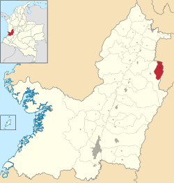
Location of the municipality and town of Caicedonia in the Valle del Cauca Department of Colombia.
|
|||
| Country | |||
| Department | Valle del Cauca Department | ||
| Established | August 3, 1910 | ||
| Area | |||
| • Municipality and town | 167 km2 (64 sq mi) | ||
| • Urban | 2.84 km2 (1.10 sq mi) | ||
| Population
(2018 census)
|
|||
| • Municipality and town | 28,825 | ||
| • Density | 172.6/km2 (447.0/sq mi) | ||
| • Urban | 23,840 | ||
| • Urban density | 8,394/km2 (21,740/sq mi) | ||
| Time zone | UTC-5 (Colombia Standard Time) | ||
| Climate | Af | ||
Caicedonia is a town and municipality in Colombia. It is located in the Valle del Cauca Department, about 172 kilometers (107 miles) from the capital city of Cali.
The town was started on August 3, 1910. It was founded by Daniel Gutierrez, Juan Bautista Angely, and other settlers. These settlers came from different parts of Colombia, like Antioquia, Caldas, and Tolima. Caicedonia was named after Lisandro Caicedo. It officially became a municipality in 1923.
Caicedonia is mostly a mountainous area. Its economy is based on farming and trade. The main crops grown and sold are corn, coffee, sugarcane, and bananas. The town is close to the Quindío Department. It is only 35 kilometers (22 miles) from Armenia, which is the capital of Quindío. Because of this, Caicedonia shares many cultural traditions with the Paisa region.
Climate in Caicedonia
Caicedonia has a tropical rainforest climate. This means it is warm all year round and gets a lot of rain. The weather is usually humid.
The nearest weather station is at El Edén International Airport. This airport is about 14 kilometers (9 miles) northeast of Caicedonia. The information below shows the typical weather patterns there.
| Climate data for El Edén International Airport , elevation 1,229 m (4,032 ft), (1981–2010) | |||||||||||||
|---|---|---|---|---|---|---|---|---|---|---|---|---|---|
| Month | Jan | Feb | Mar | Apr | May | Jun | Jul | Aug | Sep | Oct | Nov | Dec | Year |
| Mean daily maximum °C (°F) | 27.8 (82.0) |
28.0 (82.4) |
27.9 (82.2) |
27.5 (81.5) |
27.3 (81.1) |
27.4 (81.3) |
27.9 (82.2) |
28.3 (82.9) |
27.7 (81.9) |
27.1 (80.8) |
26.9 (80.4) |
27.2 (81.0) |
27.6 (81.7) |
| Daily mean °C (°F) | 22.2 (72.0) |
22.4 (72.3) |
22.2 (72.0) |
22.0 (71.6) |
22.0 (71.6) |
22.2 (72.0) |
22.4 (72.3) |
22.6 (72.7) |
22.0 (71.6) |
21.5 (70.7) |
21.5 (70.7) |
21.9 (71.4) |
22.1 (71.8) |
| Mean daily minimum °C (°F) | 16.6 (61.9) |
16.7 (62.1) |
16.8 (62.2) |
17.1 (62.8) |
17.3 (63.1) |
16.9 (62.4) |
16.6 (61.9) |
16.5 (61.7) |
16.5 (61.7) |
16.6 (61.9) |
16.7 (62.1) |
16.8 (62.2) |
16.7 (62.1) |
| Average precipitation mm (inches) | 136.1 (5.36) |
144.2 (5.68) |
194.1 (7.64) |
262.6 (10.34) |
219.6 (8.65) |
153.1 (6.03) |
105.2 (4.14) |
95.6 (3.76) |
182.9 (7.20) |
249.7 (9.83) |
264.1 (10.40) |
175.2 (6.90) |
2,164.7 (85.22) |
| Average precipitation days | 13 | 13 | 16 | 20 | 20 | 15 | 13 | 12 | 17 | 21 | 20 | 16 | 190 |
| Average relative humidity (%) | 80 | 79 | 80 | 82 | 83 | 82 | 79 | 77 | 80 | 82 | 82 | 81 | 80 |
| Mean monthly sunshine hours | 170.5 | 146.8 | 139.5 | 126.0 | 127.1 | 138.0 | 176.7 | 189.1 | 150.0 | 136.4 | 135.0 | 148.8 | 1,783.9 |
| Mean daily sunshine hours | 5.5 | 5.2 | 4.5 | 4.2 | 4.1 | 4.6 | 5.7 | 6.1 | 5.0 | 4.4 | 4.5 | 4.8 | 4.9 |
| Source: Instituto de Hidrologia Meteorologia y Estudios Ambientales | |||||||||||||
See also
 In Spanish: Caicedonia para niños
 | William Lucy |
 | Charles Hayes |
 | Cleveland Robinson |


