Calder River (Tasmania) facts for kids
Quick facts for kids Calder |
|
|---|---|
|
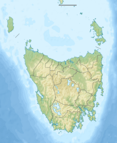
Location of the river mouth in Tasmania
|
|
| Country | Australia |
| State | Tasmania |
| Physical characteristics | |
| Main source | Campbell Ranges near Henrietta 340 m (1,120 ft) 41°10′21″S 145°41′28″E / 41.17250°S 145.69111°E |
| River mouth | Inglis River near Calder 71 m (233 ft) 41°4′8″S 145°36′39″E / 41.06889°S 145.61083°E |
| Length | 15 km (9.3 mi) |
The Calder River is a short but important river located in North West Tasmania, Australia. It flows for about 15 kilometres (9.3 mi) (about 9 miles) from its starting point in the Campbell Ranges. The river eventually joins the Inglis River near a town also called Calder.
This river is an important part of the local environment. A special area called the Calder River Conservation Area, which is about 65.21-hectare (161.1-acre) (161 acres) in size, is located right next to part of the river. This area helps protect the plants and animals that live there.
Exploring the Calder River
The Calder River begins its journey high up in the Campbell Ranges. These ranges are close to a small place called Henrietta. From there, the river flows downhill, making its way towards the coast.
As the river travels, it passes under the Murchison Highway. This highway is a major road in Tasmania. The river's path is quite direct, leading it to meet the larger Inglis River.
Where does the Calder River start and end?
The Calder River starts in the Campbell Ranges at an elevation of about 340 m (1,120 ft) (1,115 feet) above sea level. This is its source. The water then flows downhill, collecting more water as it goes.
The river's journey ends when it reaches its mouth, where it joins the Inglis River. This meeting point is near the town of Calder. At this point, the river is much lower, at about 71 m (233 ft) (233 feet) above sea level.
Who was James Erskine Calder?
The Calder River, and the nearby town of Calder, were named after an important person named James Erskine Calder. He was a significant figure in Tasmania's history.
James Erskine Calder worked as the Surveyor General of Tasmania from 1859 to 1870. A Surveyor General is like the chief map-maker and land planner for a whole region or country. Their job is to measure and map out land, which was very important for developing new areas in the past. Naming the river and town after him was a way to honor his contributions to Tasmania.
 | Ernest Everett Just |
 | Mary Jackson |
 | Emmett Chappelle |
 | Marie Maynard Daly |


