
Inglis River facts for kids
Quick facts for kids Inglis |
|
|---|---|

Wharf at the mouth of the Inglis River in Wynyard
|
|

Location of the river mouth in Tasmania
|
|
| Country | Australia |
| State | Tasmania |
| Physical characteristics | |
| Main source | Campbell Ranges Taken 507 m (1,663 ft) |
| River mouth | Bass Strait Wynyard 0 m (0 ft) 40°59′14″S 145°44′13″E / 40.98722°S 145.73694°E |
| Length | 61 km (38 mi) |
| Basin features | |
| Basin size | 471 km2 (182 sq mi) |
| Tributaries |
|
The Inglis River is a river in North West Tasmania, Australia. It starts in the Campbell Ranges near Takone. The river flows for about 61 kilometres (38 mi) before it reaches the Bass Strait at Wynyard.
The Flowerdale River is the biggest stream that flows into the Inglis River. It makes up about one-third of the 471-square-kilometre (182 sq mi) Inglis-Flowerdale catchment basin. A catchment basin is the area of land where all the water drains into a specific river or body of water.
Contents
Inglis-Flowerdale River Area


The Inglis-Flowerdale catchment area covers 616 square kilometres (238 sq mi). It includes smaller creeks like Sisters Creek and Seabrook Creek. These creeks are not direct tributaries of the main river system.
The amount of rain in this area changes throughout the year. Near the coast, about 1,000 millimetres (39 in) of rain falls each year. Further inland, about 26 kilometres (16 mi) from Wynyard, the upper parts of the catchment get more than 1,600 millimetres (63 in) of rain annually.
Much of the land in the western part of the catchment is used for tree farms. In the north and east, people use the land for farming. The Inglis and Flowerdale rivers flow through steep areas. Because of this, many native forests remain along the riverbanks. These forests help protect the rivers from farming and tree-cutting activities.
River Health and Wildlife
A study in 2003 looked at the water quality of the Inglis and Flowerdale Rivers. It found that the upper parts of both rivers and their smaller streams were quite healthy. However, the middle and lower parts of the Inglis River were not as healthy.
Scientists looked at tiny creatures called macroinvertebrates in the water. These creatures are good indicators of river health. In the lower parts of the river, there were fewer healthy macroinvertebrate communities. This suggests that the river has been affected by things like sedimentation. Sedimentation happens when soil and dirt wash into the river from nearby tree farms, gravel pits, and poorly managed farm areas.
To help the river, people can put fences along the riverbanks. This stops livestock (like cows) from walking into the water. Planting more trees along the banks also helps. This prevents the soil from washing away, which is called erosion.
Aquatic Animals and Plants
The Inglis-Flowerdale catchment is home to several special aquatic animals.
- The Beddomeia capensis is an endangered freshwater snail. It was once found in a stream connected to Big Creek. Now, it is only known to live in a few small streams near Table Cape.
- The endangered Tasmanian giant freshwater crayfish also lives here. This is a very large freshwater crayfish.
- The Australian grayling is another threatened fish species found in these waters.
Removing Willow Trees
Between 1999 and 2000, a lot of willow trees were removed from the lower Inglis River. This happened in the Flowerdale valley. The Federal Government provided money for this project.
However, the way the trees were removed caused problems. Workers dug up the roots of the trees. This led to a lot of soil erosion along the riverbanks. Even more than ten years later, this erosion is still an issue for local farmers.
Images for kids
-
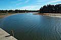
The Inglis River where it meets the sea, looking upstream.
-
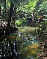
A calm part of Camp Creek, a small stream feeding the Inglis River.
