
Table Cape facts for kids
Quick facts for kids Table CapeTasmania |
|||||||||||||||
|---|---|---|---|---|---|---|---|---|---|---|---|---|---|---|---|

Overlooking Freestone Cove from Fossil Bluff with Table Cape in the background
|
|||||||||||||||

Table Cape
Location in Tasmania
|
|||||||||||||||
| Population | 324 (2011) | ||||||||||||||
| Postcode(s) | 7325 | ||||||||||||||
| Elevation | 180 m (591 ft) | ||||||||||||||
| Location | 4 km (2 mi) N of Wynyard, Tasmania | ||||||||||||||
| LGA(s) | Waratah-Wynyard | ||||||||||||||
| Region | North West Tasmania | ||||||||||||||
| State electorate(s) | Braddon | ||||||||||||||
| Federal Division(s) | Braddon | ||||||||||||||
|
|||||||||||||||
Table Cape is a cool natural landmark near Wynyard in North West Tasmania, Australia. It's a special type of rock formation called a volcanic plug. The name "Table Cape" also refers to the area around this geological feature.
Imagine a giant, roundish rock with a flat top. That's Table Cape! Its northern and eastern sides drop sharply into Bass Strait, rising about 170 meters (558 feet) above the sea.
A British explorer named Matthew Flinders gave it this name. He and George Bass sailed around Van Diemen's Land (which is now Tasmania) in 1798 on their ship, the Norfolk. Flinders also named other nearby places like Circular Head and the Three Hummock and Hunter Islands.
The top of Table Cape and the land around it have very rich soil from volcanic rock. This makes it a great place for farming. The area is famous for its beautiful tulips that bloom every spring, and there's even a tulip festival! In 2011, about 324 people lived in the area that includes Table Cape.
Contents
Nature and Conservation at Table Cape
While the flat top of Table Cape is used for farming, the steep, rocky cliffs facing the ocean are mostly untouched. These parts are covered in thick scrubland. There's a special area called the Table Cape Conservation Area, which is 1.26 square kilometers (0.49 square miles) big. It helps protect the natural environment.
Tiny Snails Need Help
A tiny, endangered freshwater snail called Beddomeia capensis lives only in a few small streams on Table Cape. It's also found in one stream near Calder. Sadly, recent checks have only found these snails in two unnamed streams near the Table Cape Lighthouse. The total length of these streams where they live is less than 80 meters (262 feet).
The number of these snails is shrinking because their homes are being damaged by farming. They also face competition from other types of snails that have been brought to the area.
Aboriginal History at Table Cape
The land around Table Cape is the traditional home of the Tommeginer clan of Aboriginal Tasmanians. It's believed that this tribe built stone fish traps in the ocean at nearby Freestone Cove. These traps are still visible today.
Table Cape Lighthouse History
The Table Cape Lighthouse is a historic lighthouse that stands on the 120-hectare Table Cape State Reserve. You can even take tours of it since 2010!
Why the Lighthouse Was Built
After two shipwrecks, the Emma Prescott in 1867 and the Orson in 1884, people decided a lighthouse was needed. It would help guide ships safely into the port of Wynyard, located on the Inglis River.
The lighthouse was designed by Huckson and Hutchinson from Hobart. The light itself came all the way from Chance Brothers in England. A local builder named John Luck built the lighthouse. The project faced some challenges. The roads leading to the building site were very bad, and the bricks made in the nearby town of Burnie weren't good enough. So, they had to bring bricks from Victoria instead!
Lighthouse Life and Changes
The Table Cape Lighthouse first shone its light on August 1, 1888. It's about 25 meters (82 feet) tall and 8.5 meters (28 feet) wide at its base. Just 17 days after it opened, the head lighthouse keeper's 14-month-old son sadly passed away from illness. Because of terrible weather, the undertaker suggested burying the child nearby. A small gravesite can still be found there today.
Originally, the lighthouse used oil for its light. In 1920, it was changed to work automatically using acetylene gas. By 1923, the lightkeepers (the people who lived and worked at the lighthouse) were no longer needed. Their cottages were torn down in 1926 after falling apart. In 1979, the lighthouse was connected to electricity. An electric beacon with backup batteries was installed. This new light can be seen from about 16 nautical miles (30 kilometers or 18 miles) away.
Gallery
-
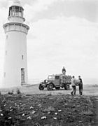
Table Cape Lighthouse in 1948
-
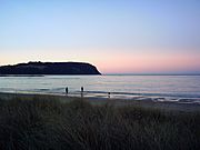
Table Cape by dusk
-
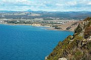
View from Table Cape lookout


