Caldwell, New South Wales facts for kids
Quick facts for kids CaldwellNew South Wales |
|
|---|---|

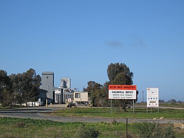
Rice silo at Caldwell
|
|
| Postcode(s) | 2710 |
| Elevation | 90 m (295 ft) |
| Location | |
| LGA(s) | Murray River Council |
| County | Cadell |
| State electorate(s) | Murray |
| Federal Division(s) | Farrer |
Caldwell is a small village community in Australia. It's located in the central southern part of a region called the Riverina. This area is known for its farming, especially rice.
Caldwell is part of the Deniboota Irrigation Area. This means it gets water for farming through a special system. The village is about 45 kilometres (28 mi) west of a larger town called Deniliquin, New South Wales. It's also close to Tantonan, just 10 kilometres (6.2 mi) to its northwest.
Caldwell's History
Caldwell might be a small place, but it has its own history. One interesting part of its past involves its Post Office.
The Caldwell Post Office
The Caldwell Post Office was an important place for the community. It first opened its doors on 21 June 1926. For many years, it helped people send letters and packages. It also connected the community to the outside world.
However, like many small post offices, it eventually closed. The Caldwell Post Office stopped operating in 1970. Even though it's gone, it's a reminder of the village's past.
 | Audre Lorde |
 | John Berry Meachum |
 | Ferdinand Lee Barnett |


