
California Historical Landmarks in Merced County facts for kids
Merced County, California, is a place rich in history, and many of its important sites are recognized as California Historical Landmarks. These special places help us remember the past and understand how our communities grew. From old inns to historic passes, each landmark tells a unique story about the people and events that shaped this part of California. Let's explore some of these fascinating historical spots!
Contents
Discovering Merced County's Historic Landmarks
Merced County is home to several important historical landmarks. These sites are officially recognized for their special meaning to California's past. Learning about them helps us connect with history in a real way.
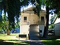
Canal Farm Inn: A Historic Stop
The Canal Farm Inn is a landmark located at 1460 E. Pacheco Blvd. in Los Banos. This inn has been a part of the community for a long time. It likely served as a resting place for travelers and a center for local activities in the past. Imagine people stopping here after a long journey!

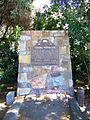
Los Banos Creek: A City's Namesake
The city of Los Banos gets its name from a significant water source, Los Banos Creek. The landmark is found at Los Banos Park, 803 E. Pacheco Blvd. This creek was vital for early settlers and continues to be an important natural feature in the area. Water sources were always key to where towns were built.

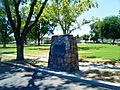
Merced Assembly Center: A Place of History
The Merced Assembly Center is a historical site located at the Merced County Fairgrounds in Merced. During World War II, this site was used as a temporary place where many Japanese Americans lived for a short time. They were moved here from their homes before being sent to more permanent relocation centers. This landmark reminds us of a challenging period in American history and the experiences of many families.

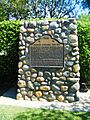
Pacheco Pass: A Mountain Gateway
Pacheco Pass is a historic mountain pass located at the Romero Overlook near Los Banos. This pass was a very important route for travelers and traders for many years. It allowed people to cross the mountains and connect different parts of California. Imagine pioneers and wagons making their way through this very pass!

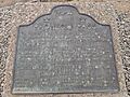
Snelling Courthouse: A Glimpse into Justice
The Snelling Courthouse is a landmark on Main St. in Snelling. This old courthouse played a role in the legal history of Merced County. Courthouses are places where laws are upheld and justice is sought. This building stands as a reminder of how communities organized themselves and managed legal matters in earlier times.

Images for kids
-
The historic Canal Farm Inn in Los Banos.
-
A view of Los Banos Creek, which gave the city its name.
-
The Merced Assembly Center site, a significant historical landmark.
-
The historical marker for Pacheco Pass at the Romero Visitor Center.
-
The historic Snelling Courthouse.
