
California Historical Landmarks in Napa County facts for kids
Napa County, California, is a beautiful place known for its rolling hills and vineyards. But it's also full of amazing history! All over California, there are special spots called California Historical Landmarks. These are places that played a big part in the state's past. They could be old buildings, important sites, or even graves of famous pioneers.
In Napa County, you can find many of these landmarks. They tell stories about how people lived, worked, and built communities long ago. Exploring these sites is like taking a trip back in time. You can learn about the early settlers, the start of California's famous wine industry, and other interesting events that shaped the area.
Contents
Exploring Napa County's History
Famous Wineries and Farms
Napa County is famous for its vineyards, and some of the oldest ones are historical landmarks.
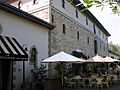
The Beringer Brothers Winery in St. Helena (Landmark 814) is one of the oldest continuously operating wineries in Napa Valley. It was founded by brothers Jacob and Frederick Beringer in 1876. Imagine making wine there over 140 years ago!
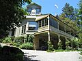
Another very old winery is the Charles Krug Winery (Landmark 563), also in St. Helena. Charles Krug started his winery in 1861. He is often called the "Father of Napa Valley winemaking" because he helped the wine industry grow so much.
The Schramsberg Vineyards (Landmark 561) near Calistoga is another historic spot. It was founded in 1862 by Jacob Schram. This winery became famous for making sparkling wines, like champagne.
Long before the big wineries, there were mills. Chiles Mill (Landmark 547) in St. Helena was built in 1846 by Joseph Ballinger Chiles. It was a grist mill, which means it ground grain into flour. This was a super important job for early settlers.
The Old Bale Mill (Landmark 359) is another grist mill, located in Bale Grist Mill State Historic Park near St. Helena. Dr. Edward Bale built it in 1846. It's one of the few water-powered mills left in California. You can still see its huge water wheel!
Pioneer Stories
Many landmarks honor the brave people who first settled in Napa County.
George Yount's Blockhouse (Landmark 564) in Yountville is a reminder of one of Napa Valley's first American settlers. George C. Yount arrived in 1831 and built a fort-like blockhouse to protect his family and neighbors.
You can also visit the Grave of George Yount (Landmark 693) in Yountville. He was buried in the George C. Yount Pioneer Cemetery. His story shows how tough and determined the early pioneers were.
Calistoga's Early Days
The town of Calistoga has many landmarks that tell its unique story.
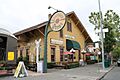
The Calistoga Depot (Landmark 687) is an old train station built in 1868. It was the end of the line for the Napa Valley Railroad. This depot helped bring visitors to Calistoga's famous hot springs.
Many early buildings in Calistoga are also landmarks. The Hudson Cabin (Landmark 683), Kelsey House (Landmark 686), Sam Brannan Cottage (Landmark 685), Sam Brannan Store (Landmark 684), and York's Cabin (Landmark 682) all show what life was like in the early days of this resort town. Sam Brannan was a very important person in Calistoga's history. He bought land and developed the town into a popular spa destination.
Unique Places to See
Napa County also has some other interesting historical spots.
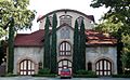
The First Presbyterian Church (Landmark 878) in Napa was built in 1874. It's a beautiful old church that shows the history of the community.
The Veterans Home of California Yountville (Landmark 828) is a very important place. It was established in 1884 to care for veterans who served our country. It's one of the largest veterans' homes in the United States.
Robert Louis Stevenson State Park (Landmark 710) is named after a famous writer. Robert Louis Stevenson, who wrote "Treasure Island," spent his honeymoon here in 1880. He even wrote about his time in the area.
Finally, there's Litto's Hubcap Ranch (Landmark 939) in Pope Valley. This is a really unique spot! It's a folk art environment created by a man named Litto. He used thousands of old hubcaps to make amazing sculptures and designs. It's a fun and quirky piece of 20th-century art.
Images for kids
-
The historic Beringer Brothers Winery.
-
The old Calistoga train depot.
-
The Charles Krug Winery, a pioneer in Napa Valley.
-
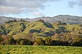
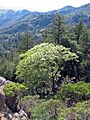
Rolling hills near Chiles Mill.
-
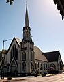
The First Presbyterian Church in Napa.
-
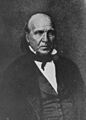
A portrait of George C. Yount, an early Napa Valley settler.
-
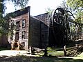
The historic Old Bale Mill.
-
Robert Louis Stevenson State Park.
-
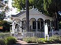
The Sam Brannan Cottage in Calistoga.
-
The historic Schramsberg Vineyards.
-
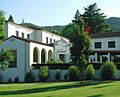
The Veterans Home of California in Yountville.


.jpg)


