Calixto García, Cuba facts for kids
Quick facts for kids
Calixto García
|
|
|---|---|

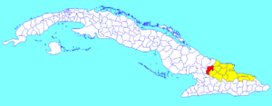
Calixto García municipality (red) within
Holguín Province (yellow) and Cuba |
|
| Country | Cuba |
| Province | Holguín |
| Seat | Buenaventura |
| Area | |
| • Total | 617 km2 (238 sq mi) |
| Elevation | 85 m (279 ft) |
| Population
(2022)
|
|
| • Total | 53,141 |
| • Density | 86.13/km2 (223.07/sq mi) |
| Time zone | UTC-5 (EST) |
| Area code(s) | +53-24 |
Calixto García is a municipality, which is like a local government area, located in eastern Cuba. It's part of the Holguín Province. About 53,141 people live there. The main jobs in Calixto García are farming, growing fruits and vegetables, and raising cattle for meat. The main town in this area is called Buenaventura. The municipality is named after Calixto García Iñiguez, a famous hero from Cuba's fight for independence.
Contents
Geography of Calixto García
This municipality includes the main town of Buenaventura. It also has smaller villages like Las Calabazas, Mir, and Sabanazo. Most of the southern part of the area is flat. In the north, you can find small hills like Bartola and La Plata.
The land is mostly used for farming. Farmers grow many different crops and raise livestock. There are also some areas with citrus trees and forests.
History of Calixto García
The history of this area is closely connected to the early days of Cuba. Over many centuries, local communities developed. They used simple methods to farm and raise animals. Later, during the time of Spanish rule, a system using enslaved labor was set up for production.
The Ten Years' War (1868-1878)
When the Ten Years' War began, people in this area quickly supported the fight. Luis Figueredo led a group of fighters in the Mijial area. On September 22, 1873, forces led by Calixto García Iñiguez fought against Fort Martillo. Other important generals like Flor Crombet and Guillermo Moncada joined him.
On July 14, 1877, generals Máximo Gómez and Antonio Maceo met in a place called Itabo. They planned a military campaign for the Holguín area.
The Little War (1879-1880)
On August 24, 1879, a group of rebels started another uprising. This happened in San Lorenzo de la Rioja, led by General Belisario Grave de Peralta. This marked the start of the Little War. However, this war, like the Ten Years' War, did not succeed. Spain continued to rule Cuba for several more decades.
The Cuban War of Independence (1895-1898)
On February 24, 1895, the call for Cuba's freedom was heard again. José Miró Argenter, along with Diego Carballo Hidalgo and Pablo García, gathered the first troops. They started the Mala Noche Uprising.
This area was an important meeting point for the Mambisa forces. These were Cuban independence fighters. General Antonio Maceo's invading army was met here by 350 horsemen from Holguín. They were led by General Luis de Ferias. On July 1, 1896, Calixto García fought and won the battle of Los Moscones.
The war ended, but Cuba did not gain full independence right away. The American intervention meant that Cuba became a republic that was influenced by American interests. This was partly due to documents like the Platt Amendment.
The Cuban Revolution (1953-1959)
In 1956, the first group of the July 26 Movement was formed in Mir. These revolutionaries helped the guerrilla fighters by spreading information and carrying out acts of sabotage.
A group of fighters from Column no. 14 operated between Buenaventura and Holguín. They were led by Oscar Orozco Viltres. On March 31, 1958, revolutionary forces led by Orlando Lara took over the Mir barracks. This was the first town taken in the eastern plains.
Later, on December 16, the Microonda de la Loma de las Mantecas was captured. On December 31, the Buenaventura barracks also fell to the rebel troops. Before the success of the Cuban Revolution, the area that is now Calixto García was divided. About half of it belonged to the Yareyal municipality.
After the Revolution
After the Revolution, the municipality was created with over 25,000 people. It was first called Mir-Buenaventura. The first political groups were based in Mir. In 1963, four districts were created for political work.
By late 1964 and early 1965, a local government was set up. It chose Buenaventura as its main office. Other organizations, like the Party and the ANAP, also moved their headquarters to Buenaventura. In 1966, the Youth Communist League and Pioneers Union of Cuba also moved.
In the same year, the municipality's name was changed to Buenaventura-Mir. In 1976, the government was officially recognized as a "popular power." With more land added from San Andrés, the municipality became known as Calixto García. It now covers 616.97 square kilometers and has over 53,000 residents.
Population of Calixto García
In 2004, the municipality of Calixto García had a population of 53,141 people. The total area is about 617 square kilometers. This means there are about 86 people living in each square kilometer.
Rivers and Water in Calixto García
The biggest and longest river in the area is the Río La Rioja. This river became well-known during Hurricane Flora. Its floods caused a lot of damage in the area. Other important water sources include the start of the Río Chaparra and other smaller rivers and streams. Some of these streams only flow at certain times of the year.
See also
 In Spanish: Calixto García (Cuba) para niños
 | Stephanie Wilson |
 | Charles Bolden |
 | Ronald McNair |
 | Frederick D. Gregory |

