Campoalegre facts for kids
Quick facts for kids
Campoalegre
|
|||
|---|---|---|---|
|
Municipality and town
|
|||
|
|||

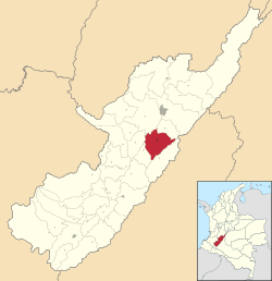
Location of the municipality and town of Campoalegre in the Huila Department of Colombia.
|
|||
| Country | |||
| Department | Huila Department | ||
| Area | |||
| • Municipality and town | 462.8 km2 (178.7 sq mi) | ||
| • Urban | 3.6 km2 (1.4 sq mi) | ||
| Population
(2020 est.)
|
|||
| • Municipality and town | 35,057 | ||
| • Density | 75.750/km2 (196.191/sq mi) | ||
| • Urban | 23,818 | ||
| • Urban density | 6,620/km2 (17,140/sq mi) | ||
| Time zone | UTC-5 (Colombia Standard Time) | ||
Campoalegre is a town and a special kind of local government area called a municipality in Colombia. It is located in the Huila Department. Think of a municipality as a region with its own local government, similar to a county or a district in other countries.
Contents
About Campoalegre
Campoalegre is home to over 35,000 people. Most of these people live in the main town area. The total size of the municipality is about 462.8 square kilometers. This makes it a significant place within the Huila Department.
Where is Campoalegre Located?
Campoalegre is found in the southwestern part of Colombia. It is part of the Huila Department, which is known for its beautiful landscapes and important rivers. The town is situated in a valley, which often means it has a warm climate.
What is a Municipality?
In Colombia, a municipality is a local administrative division. It includes a main town, which is the center of the area, and surrounding rural areas. The local government manages services like education, health, and public works for everyone living there.
Climate in Campoalegre
Campoalegre has a warm climate throughout the year. The temperature usually stays quite high, making it a tropical place. There are periods of rain and drier times, but it never gets cold like in places with four seasons.
The detailed weather information below shows the average temperatures and rainfall. This data helps us understand the typical weather patterns in Campoalegre.
| Climate data for Campoalegre (Rosales Los), elevation 553 m (1,814 ft), (1981–2010) | |||||||||||||
|---|---|---|---|---|---|---|---|---|---|---|---|---|---|
| Month | Jan | Feb | Mar | Apr | May | Jun | Jul | Aug | Sep | Oct | Nov | Dec | Year |
| Mean daily maximum °C (°F) | 31.8 (89.2) |
31.9 (89.4) |
31.5 (88.7) |
31.3 (88.3) |
31.6 (88.9) |
32.0 (89.6) |
32.5 (90.5) |
33.5 (92.3) |
34.0 (93.2) |
32.5 (90.5) |
30.8 (87.4) |
30.8 (87.4) |
32.0 (89.6) |
| Daily mean °C (°F) | 26.3 (79.3) |
26.5 (79.7) |
26.2 (79.2) |
25.9 (78.6) |
26.1 (79.0) |
26.3 (79.3) |
26.7 (80.1) |
27.5 (81.5) |
27.9 (82.2) |
26.8 (80.2) |
25.8 (78.4) |
25.7 (78.3) |
26.5 (79.7) |
| Mean daily minimum °C (°F) | 21.2 (70.2) |
21.4 (70.5) |
21.3 (70.3) |
21.2 (70.2) |
21.3 (70.3) |
21.2 (70.2) |
21.4 (70.5) |
21.9 (71.4) |
21.9 (71.4) |
21.6 (70.9) |
21.3 (70.3) |
21.1 (70.0) |
21.4 (70.5) |
| Average precipitation mm (inches) | 115.4 (4.54) |
112.6 (4.43) |
160.4 (6.31) |
131.0 (5.16) |
102.2 (4.02) |
37.3 (1.47) |
36.2 (1.43) |
23.6 (0.93) |
46.3 (1.82) |
164.0 (6.46) |
206.8 (8.14) |
169.4 (6.67) |
1,298.2 (51.11) |
| Average precipitation days | 11 | 12 | 16 | 17 | 16 | 14 | 12 | 10 | 11 | 16 | 17 | 14 | 165 |
| Average relative humidity (%) | 71 | 70 | 73 | 74 | 72 | 67 | 61 | 55 | 56 | 67 | 76 | 76 | 68 |
| Mean monthly sunshine hours | 176.7 | 144.0 | 127.1 | 126.0 | 136.4 | 138.0 | 142.6 | 142.6 | 132.0 | 148.8 | 144.0 | 158.1 | 1,716.3 |
| Mean daily sunshine hours | 5.7 | 5.1 | 4.1 | 4.2 | 4.4 | 4.6 | 4.6 | 4.6 | 4.4 | 4.8 | 4.8 | 5.1 | 4.7 |
| Source: Instituto de Hidrologia Meteorologia y Estudios Ambientales | |||||||||||||
| Climate data for Campoalegre (Hidrobetania), elevation 500 m (1,600 ft), (1981–2010) | |||||||||||||
|---|---|---|---|---|---|---|---|---|---|---|---|---|---|
| Month | Jan | Feb | Mar | Apr | May | Jun | Jul | Aug | Sep | Oct | Nov | Dec | Year |
| Mean daily maximum °C (°F) | 32.3 (90.1) |
32.6 (90.7) |
31.9 (89.4) |
31.9 (89.4) |
31.7 (89.1) |
31.6 (88.9) |
30.0 (86.0) |
32.6 (90.7) |
33.2 (91.8) |
30.5 (86.9) |
29.3 (84.7) |
29.4 (84.9) |
31.5 (88.7) |
| Daily mean °C (°F) | 27.4 (81.3) |
27.6 (81.7) |
26.9 (80.4) |
26.8 (80.2) |
27.1 (80.8) |
27.2 (81.0) |
27.3 (81.1) |
27.9 (82.2) |
28.1 (82.6) |
27.2 (81.0) |
26.3 (79.3) |
26.4 (79.5) |
27.2 (81.0) |
| Mean daily minimum °C (°F) | 21.7 (71.1) |
21.5 (70.7) |
21.5 (70.7) |
21.4 (70.5) |
21.7 (71.1) |
22.0 (71.6) |
22.1 (71.8) |
22.6 (72.7) |
22.5 (72.5) |
21.5 (70.7) |
21.1 (70.0) |
21.3 (70.3) |
21.7 (71.1) |
| Average precipitation mm (inches) | 145.5 (5.73) |
142.4 (5.61) |
176.5 (6.95) |
137.2 (5.40) |
128.9 (5.07) |
37.5 (1.48) |
34.5 (1.36) |
22.2 (0.87) |
47.8 (1.88) |
177.6 (6.99) |
254.4 (10.02) |
169.7 (6.68) |
1,440.8 (56.72) |
| Average precipitation days | 9 | 10 | 13 | 12 | 10 | 6 | 6 | 4 | 5 | 12 | 15 | 13 | 13 |
| Average relative humidity (%) | 71 | 70 | 75 | 73 | 71 | 66 | 63 | 59 | 59 | 68 | 75 | 75 | 69 |
| Source: Instituto de Hidrologia Meteorologia y Estudios Ambientales | |||||||||||||
See also
 In Spanish: Campoalegre para niños
 | Stephanie Wilson |
 | Charles Bolden |
 | Ronald McNair |
 | Frederick D. Gregory |


