Canal de l'Aqueduc facts for kids
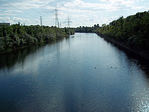
The Canal de l'Aqueduc is a special canal in Montreal, Quebec, Canada. It's like a big open-air pipe that helps bring drinking water to many homes in the city. It's a really important part of Montreal's water system.
This important canal was built a long time ago, in 1853. A city leader named Edwin Atwater was in charge of the project. You might recognize his name because a street nearby, Atwater Avenue, is named after him!
Contents
Where the Water Comes From
The Canal de l'Aqueduc gets its water from the mighty Saint Lawrence River. It starts in an area called LaSalle, which is on the southern side of the island. The water is taken from the Lachine Rapids, which are just below the Honoré Mercier Bridge.
Where the Water Goes
From LaSalle, the canal flows northeast. It passes through LaSalle and then runs between the areas of Verdun and Le Sud-Ouest. Finally, it reaches a pumping station and an underground water tank on Atwater Avenue. This spot is very close to the Lachine Canal, another famous waterway.
The Canal de l'Aqueduc is about 8,100 meters (or 8.1 kilometers) long. It's also quite wide, usually between 35 and 50 meters across.
Nature and Paths Around the Canal
Along its path, the canal is surrounded by natural wetlands. Even though the canal itself is fenced off for safety, there's a lovely park and a bicycle path right next to its southern side. This path is a great place for people to walk, run, or bike.
There are also major roads running alongside the canal. Boul. de La Vérendrye is on the northern side, and Boul. Champlain is on the southern side. Near the pumping station, you'll find Autoroute 15.
Bridges Over the Canal
Many bridges cross the Canal de l'Aqueduc, connecting different parts of the city. Here are some of them, listed from where the canal starts at the river to where it ends at the pumping station:
- Boul. LaSalle
- Avenue Dollard
- Boul. Bishop-Power/Boul. Shevchenko
- 2e Ave (This is a special bridge just for people walking!)
- Rue Crawford (Another bridge just for walkers!)
- Av. Stephens
- Av. Woodland
- Rue Jolicoeur
- Rue Galt
- Av. de l'Église
See also
 In Spanish: Canal de l'Aqueduc para niños
 | DeHart Hubbard |
 | Wilma Rudolph |
 | Jesse Owens |
 | Jackie Joyner-Kersee |
 | Major Taylor |


