
Lachine Canal facts for kids
Quick facts for kids Lachine Canal |
|
|---|---|

The canal's path through Montreal's boroughs
|
|
| Specifications | |
| Locks | 5 (originally 7) |
| Original number of locks | 7 |
| Maximum height above sea level | 65 ft (20 m) |
| Navigation authority | Parks Canada |
| History | |
| Original owner | Company of the Proprietors of the Lachine Canal |
| Principal engineer | Thomas Burnett |
| Construction began | July 17, 1821 |
| Date of first use | 1825 |
| Date completed | August 24, 1824 |
| Date extended | 1843–1848, 1873–1885 |
| Date closed | 1970 |
| Date restored | 2002 |
| Geography | |
| Start point | Old Port of Montreal |
| End point | Lachine Lock |
The Lachine Canal (canal de Lachine in French) is a special waterway in Quebec, Canada. It runs for 14.5 kilometers (about 9 miles) through the southwestern part of the Island of Montreal. The canal connects the Old Port of Montreal to Lake Saint-Louis. It passes through the areas of Lachine, Lasalle, and Sud-Ouest.
Before the canal was built, there was a lake called Lac à la Loutre. You can see this lake and its rivers on old maps of Montreal from the 1700s.
The canal's name comes from the French word for China (la Chine). Early European explorers hoped to find a water route from New France to Asia. They thought this area might be the start of a path to China. That's why the region where the canal was built was named Lachine.
Even though some industrial waste was put into the canal in the past, its water quality is now considered good.
Contents
History of the Lachine Canal


The land where the canal is located was first given to the Sulpician Order by the King of France. For over 130 years, many groups tried to build a canal here. They wanted ships to avoid the dangerous Lachine Rapids. These rapids made it hard for boats to travel further up the Saint Lawrence River.
After many tries, a group of people finally succeeded. This group included a young Scottish immigrant named John Redpath. John Richardson was in charge of the project, and Thomas Burnett was the main engineer.
Why the Canal Was Needed
The Lachine Canal was built to help ships get around the Lachine Rapids. Before the canal, boats traveling past Lachine had to unload their goods and passengers. People then had to carry everything for about 8 or 9 miles from Montreal's port to the village of Lachine. There, they could get back on a boat. This process was called "portage." The canal made this much easier and faster.
Building the First Canal
Work on the canal began on July 17, 1821. It was led by Chief Engineer Thomas Burnett. The first canal was 14 kilometers (about 8.7 miles) long. It had seven locks, which are like water elevators for boats. Each lock was 30 meters (98 feet) long, 6 meters (20 feet) wide, and 1.5 meters (5 feet) deep. The new canal officially opened in 1825.
The canal helped turn Montreal into a very important port city. It also attracted many industries to its banks. This happened because the Sulpician Order, who owned the land, started selling plots of land along the canal.
Making the Canal Bigger
During the 1840s, the Lachine Canal was made deeper. This allowed larger ships to use it. Also, water power (called hydraulic power) was introduced to the factories along its banks. This meant the canal was no longer just a way to avoid the rapids. It became a key industrial area in Montreal.
The canal's growth had two big effects on Montreal:
- It created a route around the Lachine rapids, opening the upper St. Lawrence River to navigation. This made Montreal a better place for trade than Quebec City.
- It led to the creation of new industrial areas outside the city center.
New working-class neighborhoods like Griffintown, St. Henri, and Pointe St. Charles grew because of the canal. Montreal's population grew more than four times between the mid-1800s and early 1900s.
Powering Industries
One main reason for the canal's growth was the access to hydraulic power. This power came from the deeper canal in the 1840s. Factories along the canal used this energy source to grow.
By the late 1800s, factories started using steam power instead of water power. This meant they didn't rely on the canal for energy anymore. They could build factories further away from the canal. The new railway system also helped industries spread out.
Even though the Lachine Canal was a huge help for Montreal and Quebec, it also affected Canada's Maritime Provinces. It made Montreal a bigger shipping center, which meant less business for ports in the Maritimes.
More Enlargements
The canal was made bigger twice more. The first time was between 1843 and 1848. Five new, larger locks replaced the original seven. These new locks were 61 meters (200 feet) long, 13.5 meters (44 feet) wide, and 2.7 meters (9 feet) deep.
The second enlargement happened between 1873 and 1885. The locks were made even longer (82 meters or 269 feet) and deeper (4.3 meters or 14 feet). This was done because factory owners wanted more power from the canal. They also complained that the water current was too slow.
Soon after the canal opened, Montreal's business leaders created a harbor commission. One of its presidents, John Young, ordered the canal to be deepened so bigger boats could pass through.
The Canal and Railways
Railway transportation became very important for Montreal. The Grand Trunk Railway had a large workshop in Point St. Charles. This railway connected Montreal to the Atlantic Ocean even in winter. It was also a link to the rest of the Grand Trunk railway line, which went from Toronto to Maine. The Lachine Canal was a major hub for transportation because it connected the ocean to the inside of Canada and America.
Closing of the Canal
The canal worked well until about 1950. But it couldn't be made bigger to handle the even larger ships that were being built. In 1959, the St. Lawrence Seaway opened. This new, larger waterway replaced the Lachine Canal. The Lachine Canal was finally closed to shipping in 1970.
The closing of the canal caused problems for the neighborhoods along its banks. Industries and shipping patterns changed, leading to economic difficulties in those areas.
Current Canal Use
The Lachine Canal was reopened in 2002 for pleasure boats. It has a guaranteed depth of 2 meters (6.6 feet). The bridges over the canal have a clearance of 2.43 meters (8 feet).
Locks of the Canal

Since 1848, the canal has had 5 locks:
- Lachine (1 lock)
- Côte-Saint-Paul (1 lock)
- Saint-Gabriel (1 lock)
- Old Port of Montreal (2 locks)
When it first opened in 1825, the canal had seven locks.
Lachine Canal National Historic Site
The Lachine Canal is now a National Historic Site of Canada. It is officially called the Lachine Canal National Historic Site of Canada. The The Fur Trade at Lachine National Historic Site is also located near the western end of the canal.
Lachine Visitor Services Centre
The Lachine Visitor Services Centre is located at the entrance to the canal in Lachine, Quebec. This center has exhibits about how the canal was built and made bigger. It also offers information and guided tours. There's a gift shop, lookout spots, and an outdoor walking trail. The center is open during certain seasons.
Recreation and Fun
In 2002, the Lachine Canal was reopened for fun activities like boating. The areas along the canal have been redeveloped. There's an ongoing project to clean up old oil spills in the water.
The banks of the canal are great for bicycling and rollerblading. Parks Canada offers guided tours of the canal by walking, biking, and boat during the summer.
The Lachine Canal became a place for leisure after the St. Lawrence Seaway opened. The last industries stopped using the canal system in 1970. In 1977, a bike path was created along the entire canal. In 2009, the Lachine Canal bike path was even ranked third on Time Magazine's list of the top 10 urban bike paths in the world!
Crossings Over the Canal
.jpg)
Here are some of the bridges and tunnels that cross the Lachine Canal, from east to west:
- Canadian National (railway)
- Rue Mill
- Autoroute 10
- Canadian National (railway)
- Rue Wellington (with a closed road tunnel underneath)
- Rue Des Seigneurs
- Rue Charlevoix (with a Metro Line 1 (Green) subway tunnel underneath)
- Avenue Atwater (for walking)
- Avenue Atwater (tunnel)
- Canadian National (railway)
- Rue Beaudoin (for walking)
- Rue Saint Rémi (tunnel)
- Autoroute 15/Autoroute 20
- Côte Saint Paul (for walking and cycling)
- Boulevard Monk
- Halte Notre-Dame park (for walking)
- Boulevard Angrignon
- Rue Senkus (for walking)
- Pont Lafleur and Pont Gauron (two bridges next to each other)
- Route 138
- Canadian Pacific/ Rockfield Bridge (railway)
- Chemin du Musée
- Chemin des Iroquois (crosses one lock)
Images for kids
-
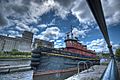
Tugboat Daniel McAllister, with grain elevators behind, Lachine Canal.
-
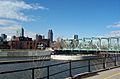
A bridge over the Lachine Canal, in sight of downtown Montreal
-
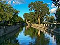
Lachine Canal
-

Two people skate on the frozen canal. (January 2011).


See also
 In Spanish: Canal de Lachine para niños
