Candlemas Island facts for kids

South Sandwich Islands
|
|
 |
|
| Geography | |
|---|---|
| Coordinates | 57°05′S 26°39′W / 57.083°S 26.650°W |
| Highest elevation | 550 m (1,800 ft) |
| Highest point | Mount Andromeda |
| Administration | |
|
United Kingdom
|
|
| Demographics | |
| Population | Uninhabited |
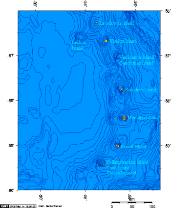
Candlemas Island (called Isla Candelaria in Spanish) is a small island where no one lives. It is part of the Candlemas Islands group. These islands are found in the South Sandwich Islands. Candlemas Island is about 2 kilometers (1.2 miles) away from Vindication Island. A narrow stretch of water called the Nelson Channel separates them.
Volcanoes and Mountains
Candlemas Island is home to an active volcano. This volcano is named Lucifer Hill. It is a type of volcano called a stratovolcano, which means it's tall and cone-shaped. Lucifer Hill is on the northwest side of the island. It showed signs of activity in 1911. Later, in 1953 and 1954, people saw glowing lava flowing from it.
The island also has two peaks covered in glaciers. These are Mount Andromeda and Mount Perseus. Mount Andromeda is the highest point on Candlemas Island. It reaches a height of 550 meters (1,804 feet).
Naming the Island's Points
The southeast tip of Candlemas Island has a special name: Shrove Point. Its coordinates are 57°4′S 26°39′W / 57.067°S 26.650°W. This point was named by people from the Discovery Investigations. They were on a ship called the Discovery II. They explored and mapped this area on March 4, 1930. This day was Shrove Tuesday, which is how the point got its name.
Another important spot is Clapmatch Point. This point forms the southwest tip of Candlemas Island.
See also
 In Spanish: Isla Candelaria para niños
 | Victor J. Glover |
 | Yvonne Cagle |
 | Jeanette Epps |
 | Bernard A. Harris Jr. |

