Canillas de Albaida facts for kids
Quick facts for kids
Canillas de Albaida
|
||
|---|---|---|
 |
||
|
||
| Country | ||
| Region | ||
| Province | ||
| Area | Axarquía | |
| Area | ||
| • Total | 33 km2 (13 sq mi) | |
| Elevation | 630 m (2,070 ft) | |
| Population
(2018)
|
||
| • Total | 732 | |
| • Density | 22.2/km2 (57.5/sq mi) | |
| Demonym(s) | Canillero | |
| Time zone | UTC+1 (CET) | |
| • Summer (DST) | UTC+2 (CEST) | |
| Website | http://www.canillasdealbaida.es | |
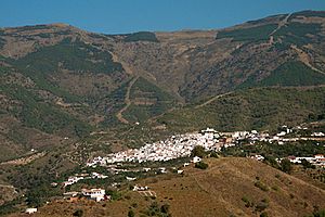
Canillas de Albaida is a small town in southern Spain. It is located in the province of Málaga, which is part of the Andalusia region. About 800 people live here. The people from Canillas de Albaida are called Canilleros.
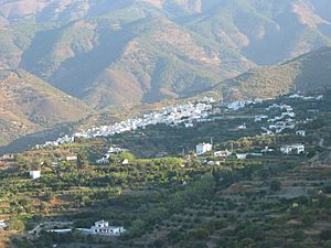
This village is one of many traditional Andalusian "white villages". These villages are known for their bright white houses. They are often found around the edges of national parks.
Since the year 2000, Canillas de Albaida has grown a lot. More tourists visit, and more people from northern Europe have moved here. This has led to new restaurants and shops. The road to the coast has also been improved.
The main way people earn a living here is through farming. Farmers grow avocados, raisins, and olives. They also make wine from moscatel grapes. Many vegetables are grown on old terraces for local use. Most farming is done by hand, often with the help of mules. Even with new changes, the village has kept its traditional way of life.
What is Canillas de Albaida Like?
The village is right next to the Sierras of Tejeda, Almijara and Alhama Natural Park. This park is a great place for wildlife and hiking. The highest point nearby is La Maroma, which is a tall mountain. It stands 2,068 meters (about 6,785 feet) above sea level.
Canillas de Albaida itself is about 576 meters (about 1,890 feet) above sea level. It is about 50 kilometers (31 miles) from the city of Málaga. It is also very close to another village called Cómpeta, just 2.5 kilometers away.
Canillas de Albaida is part of the "Route of Sun and Wine." It is also one of the "white villages of the Costa del Sol." The village has narrow, winding, and steep streets. Its houses are all painted white. The area of the municipality is 33 square kilometers (about 13 square miles). All of this area is inside the Natural Park.
A Look at Canillas de Albaida's History
Some experts believe that Canillas de Albaida was first mentioned in the 13th century. It was part of a larger area called Al-hawz. The village was named Albaida, which means "white," because of the many white flowers in the area.
In 1487, the Catholic Monarchs took control of Vélez-Málaga. Canillas de Albaida then became part of the lands controlled by King Ferdinand. Later, in 1569, many people in the village, mostly Moors, joined a rebellion. They fought against the rule of Philip II. They were eventually defeated in a battle.
After the rebellion, new Christian families moved to Canillas de Albaida. These families came from nearby parts of the province and other areas of Andalusia. The village then grew with people focused on farming. They mainly grew grapevines, cereals, and olives.
See also
 In Spanish: Canillas de Albaida para niños
 | Emma Amos |
 | Edward Mitchell Bannister |
 | Larry D. Alexander |
 | Ernie Barnes |


